- Austin leaders consider expanding wildfire protection plan
- Large hail, strong winds and tornado threat possible into Thursday evening
- Large hail, tornado threat possible Thursday evening
- Jaccob Slavin scores in OT as the Hurricanes beat the Capitals in Game 1 of their 2nd-round series
- 5 On Your Side: What happened to cars flooded during Hurricane Helene?
Maze: Worst of severe weather is over, but more storms are on the way this week
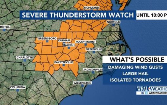
Raleigh, N.C. — The worst of Wednesday’s storms had moved out of central North Carolina by 7 p.m., meteorologist Mike Maze said, but the rest of the week will be soggy.
The area was under a severe thunderstorm watch until 10 p.m. Wednesday, including Wake, Johnston, Lee, Harnett and Cumberland counties.
But Maze said that while thunderstorms could pop up during the evening, they’re not likely to become severe.
“Our atmosphere has been turned over; the energy’s been used,” Maze said.
Sign up to recieve WRAL weather alerts to your device
Wind damage was reported in some areas, including on Erwin Chapel Road in Harnett County, where a tree had fallen.

About an inch of rain had fallen in Wake County on Wednesday, and about two inches had fallen in central Bladen County.
“This is only the beginning of a wetter weather pattern that is shaping up over the next several days,” Maze said.
A cold front moves in Friday, and it will interact with tropical moisture to keep showers and storms in the forecast until Tuesday.
