- Paramedics' vacation could turn to work as they hunker down in Jamaica, await Hurricane Melissa
- Hurricane Melissa, at Category 5, is set to slam into Jamaica as island’s strongest recorded storm
- Melissa strengthens to a Category 5 hurricane as it nears Jamaica
- Tropical Storm Melissa nears hurricane strength and dumps torrential rain on Caribbean
- NWS: Flood watch extended for San Antonio, much of Hill Country
FORECAST: More Rain and More Flooding
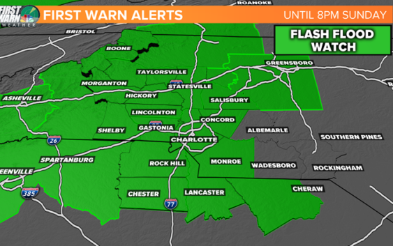
More rain continues through the day and the flooding we have seen for Caldwell, Burke, Catawba and Alexander County’s is substantial! An estimated 6-10 inches has fallen over the past 60 hours. More rain is expected today (another 1-4″ across our area) so more flash flooding and rising creek/river/stream levels are expected!
The reasoning above is why we have been under a Flash Flood Watch since yesterday and this will carry into this evening when the rain should be less widespread giving those areas impacted the hardest a slight break before MORE rain is possible Monday and again Wednesday.

WEATHER WCNC
High temperatures will likely be in the upper 70’s to the lo 80’s today under overcast skies. Scattered to widespread rain is anticipated through the afternoon eventually taking a break later in the evening. This is all credited to a nearly stationary low pressure system pumping in some tropical moisture. Tomorrow will be in the lower 80’s around Charlotte with scattered rain returning tomorrow morning AND even thunderstorms during the afternoon.
MOST of Tuesday looks to be dry before more rain moves back in Wednesday giving the all clear by late Thursday and Friday. Friday should be sunny and feel great since this muggy air will have said goodbye. That looks to be the pick of the week so something to look forward to!
Enjoy the rest of this lazy feeling Sunday!
-Chris Mulcahy
Copyright 2018 WCNC