- Mosquito activity on the rise due to rainfall, flooding across Texas
- Volunteers help Conroe community clean up in wake of flooding in Montgomery County
- Why leaders are urging NC residents to start hurricane prep now
- Storms could produce hail, damaging winds south of Charlotte
- Large hail and strong winds cause damage in San Marcos and the Hill Country
Raleigh, Fayetteville areas at risk for severe weather today
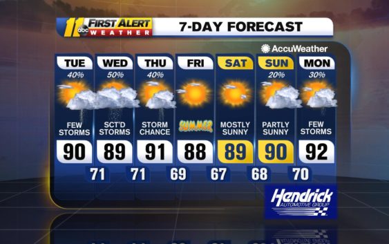
ABC11 is in First Alert Mode as parts of central North Carolina are at risk for severe weather on Tuesday.
Heat and humidity will return Tuesday with temps topping out around 90. Pop-up showers and storms are possible during the afternoon into the evening.
One or two of them may get strong enough to produce a severe storm.
Because of this, most areas in the ABC11 viewing are at a marginal risk for severe weather.
There is a marginal risk for severe weather today (Category 1 of 5) for most of our area. The biggest threat will be from damaging winds, though some storms may form some hail. #ncwx pic.twitter.com/edWJDqLg7S
— Don Schwenneker (@BigweatherABC11) June 18, 2019
The biggest threats are damaging wnds and hail.
Tonight, the showers will die out and temps will be similar to last night with lows in the 70s.
Wednesday will be similar to Tuesday with temps just a degree or two cooler. Though we could see a storm fire again, we are not under a risk for severe weather.
Thursday will feel like today with temps back in the low 90s and the severe chances return again.
The front that will bring the storms on Thursday will bring in some lower humidity and temps in the upper 80s for Friday, which is also the official start to summer.
Saturday will bring the sunshine as well with temps around 90. It should be the better of the two days on the weekend.
Sunday will have more clouds work through and it gets a little warmer with temps in the low 90s.
Have a great Tuesday!
Big Weather
Check the radar anytime with the free AccuWeather app for iPhone and Android today!
Copyright © 2019 WTVD-TV. All Rights Reserved.