- Central Texas school districts adjusting Friday schedules due to potential severe weather
- Hutto ISD announces early dismissal Friday due to severe weather risk
- Hutto ISD schools dismissing early Friday due to possible severe weather
- Crews responding to wildfire in Boiling Spring Lakes
- Live radar: Strong storms end Thursday evening; more severe weather expected on Friday
10 evacuated from woman's shelter in Smithfield after overnight flooding
JOHNSTON COUNTY, N.C. (WTVD) — ABC11 is in First Alert Mode as parts of central North Carolina are at risk for severe weather Friday.
Storms pushed through Thursday, bringing heavy rain and high wind. Those same issues remain a possibility Friday.
Storms pushed through Thursday, bringing heavy rain and high wind. Those same issues remain a possibility Friday.
There is a Marginal Risk for severe weather for the southern 2/3’s of our viewing area. Biggest threats from damaging wind, and possibly some localized flooding. #ncwx pic.twitter.com/AwpCgvH6fE
— Don Schwenneker (@BigweatherABC11) July 12, 2019
A Flash Flood Warning was issued for Johnston and Wayne counties until 8:30 a.m. Friday.
Excessive rain overnight caused flooding in several counties including Johnston.
Roughly 18-20 inches of water reportedly pooled near Skyland Drive off Highway 210 in Smithfield.
That high water caused the evacuation of woman’s shelter in the area. Ten people from the shelter were moved to an undisclosed location.
10 people had to be evacuated from a women’s shelter in Smithfield this morning. This debris line shows how high flood waters got because of overnight rain. #ABC11 pic.twitter.com/4kFITxeXzO
— Ana Rivera (@AnaRiveraABC11) July 12, 2019
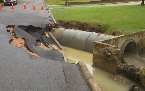
The rising waters caused part of Vermont Street near Parker Street to collapse. Smithfield residents said they’ve never seen something like this, even during Hurricane Matthew
A portion of Vermont Street near Parker Street has collapsed in Smithfield. Neighbors say they’ve never seen something like this—even during Hurricane Matthew. #ABC11 pic.twitter.com/v6d6nhdj0k
— Ana Rivera (@AnaRiveraABC11) July 12, 2019
Officials said the water started to recede around 5:30 a.m.
The threat for flooding continues late into Friday evening.
Don “Big Weather” Schwenneker said areas that experienced flooding Thursday night and Friday morning could flood again Friday evening.
Drivers are reminded to avoid roadways covered by high waters.
Rain chances will continue throughout the end of the week but should significantly decrease Saturday.
As Sunday arrives, the region will dry out, leaving a few dry days to start out next week.
Copyright © 2019 WTVD-TV. All Rights Reserved.