- 'She will be greatly missed': Memorial service held for 77-year-old woman killed in SA floods on June 12
- San Antonio officials warn residents to stay vigilant ahead of possible Thursday nights floods
- Flooding is possible in South Texas as we head into July 4th. Here's where.
- Flood Watch issued for counties west of San Antonio | Weather Impact Alert
- Possible heavy downpours and flooding in Hill Country counties | Weather Impact Alert
Storms flood parts of Smithfield; more severe weather expected Friday
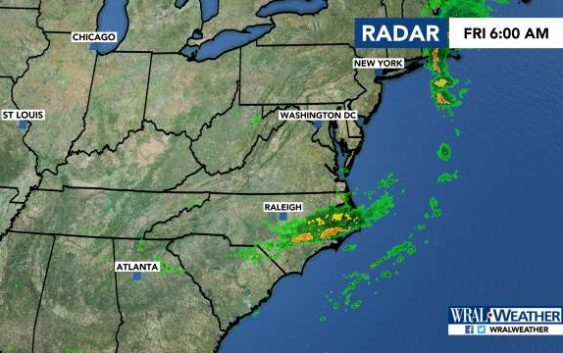
Smithfield, N.C. — Strong storms flooded parts of central North Carolina overnight, and more storms are expected Friday evening.
Ten people were escorted out of a shelter for families in Smithfield through about 18 inches of water, Johnston County authorities said.
Numerous roads in Smithfield were flooded, 911 dispatchers said, including at Venture Drive and Outlet Center Drive.
WRAL meteorologist Elizabeth Gardner said the lingering storms would move out of Wake and Durham counties by 7:30 a.m., although they could last a little longer in Fayetteville.
Lunchtime will be quiet in the Triangle, but more storms will move in Friday evening.
Durham, Raleigh, and areas to the south and east are under a level 1 threat for severe weather. Isolated storms could bring damaging winds, heavy rain and small hail to those parts of the state.
A cold front is to thank for the storms, although high temperatures this weekend will stay in the low 90s. Friday’s high will be 92 degrees.
The following week will be calmer, although North Carolina could see the remnants of Tropical Storm Barry, which is expected to develop into a hurricane before making landfall in Louisiana, as heavy rain during the middle of the week, Gardner said.
