- $40 million to go to underserved SC counties for Hurricane Helene recovery. Here's what you need to know.
- Family honors Air Force veteran Derwin Anderson Jr. after he died in June flash floods
- City of Wilmington addresses flooding on New Centre Drive
- Harnett County fire: Two homes damaged
- Medical examiner identifies 13th victim from massive flash flood in San Antonio
Thunderstorms likely, flooding possible through afternoon, evening in the Triangle
Raleigh, N.C. — Much of central North Carolina is under the threat of severe weather Tuesday as a cold front moves through the region, bringing the possibility of heavy downpours, gusty winds and lightning.
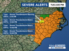
At 2:30 p.m., a severe thunderstorm warning was in effect for Harnett, Johnston and Wake counties until 3:30 p.m. A severe thunderstorm watch, which means conditions are right for storms to form, is in effect for much of central North Carolina until 10:00 p.m.
A flash flood watch was issued for numerous counties, including Durham, Johnston, Orange, Wake and Wilson, from 12 p.m. to 11 p.m.
Motorists warned about dangers of heavy rain, high winds forecast during evening rush hour
With the worst of the storms expected during the evening rush hour, the North Carolina Department of Transportation issued a warning for drivers about the risks related to flood-covered roads.
“If you do have to travel, drive defensively, slow down and leave extra space between your vehicle and those in front of you,” Marty Homan, NCDOT spokesman said. “Never drive through standing or rushing water. Six inches of water will reach the bottom of most cars, causing possible loss of control and stalling. It takes just a foot of water to carry away many vehicles, while two feet of rushing water can carry many pickups and SUVs off a road into possible floodwater. Most flood-related drownings occur when someone drives through standing or rushing water and their vehicle is swept away.”
He offered these additional tips for safe driving in bad weather:
- If your car starts to hydroplane, take your foot off the gas, apply the brakes in a steady, slightly firm manner and steer in the direction of the skid. If you have a manual transmission, push in the clutch and let the car slow down on its own;
- For vehicles with anti-lock brakes, apply more steady pressure to the brakes, but avoid pumping them;
- If the rain is extremely heavy, pull over in a safe area, either in a parking lot or on the roadside, with your emergency flashers on. Park far from any trees or other tall objects and wait for the weather to improve;
- If line markings on the road are not visible, do not take a chance. Turn around. It is possible the road was washed away and the water may be much deeper than you expect;
- Do not drive into standing water that can hide hazards, including debris and fallen trees or powerlines;
- Allow more travel time by reducing your speed by at least five to 10 miles per hour;
- Allow at least twice the normal following distance;
- Signal for turns ahead of time and brake early as you near a stop. Roads are the most slippery in the first 10 to 15 minutes of rainfall;
- Pay attention to advisories and directions from law enforcement, and to any signs;
- Heavy rainfall often saturates the ground beneath trees with shallow root systems. Be especially careful when driving around a curve as a tree could be down on the roadway and you don’t have time to stop;
- If you must drive, be sure your tires and brakes are in good working condition;
- Be patient and do not pass lines of traffic;
- Turn on your headlights, as required by North Carolina law, while using your windshield wipers – regardless of the time of day; and
- If a traffic signal is knocked out by a storm, regard the intersection as a four-way stop. If two or more vehicles arrive at the same time, the car to the right has the right of way and after signaling, may move in any direction. If two facing vehicles approach the intersection at the same time, any car traveling straight ahead or turning right has the right of way.
Storm risk builds through Tuesday afternoon
During the noon hour, a cell with heavy rain, lightning and winds moved through Wake County. WRAL meteorologist Elizabeth Gardner said residents should be prepared for damaging winds and torrential downpours.
Several areas are under a Level 2 risk for severe weather, including Fayetteville, Rocky Mount and Wilson, while Durham and Charlotte are under a Level 1 risk of severe weather, according to the storm prediction center.
Raleigh and Wake County are on the dividing line for the risk, so residents should expect stormy weather as well.
Gardner said an approaching cold front moving eastward will trigger the storms and bring cooler weather in its wake after several days of sweltering heat and humidity blanketed the Triangle.
Tuesday’s high is expected to be 80 degrees.

Rain fell in the early hours of Tuesday but cleared before the morning commute. More rain will move in by lunchtime, bringing the chance for scattered severe storms.
Those storms will move eastward throughout the afternoon, and a bigger system moves through the Triangle in the evening and into the night. That’s when severe weather will be most widespread, with the biggest risk being damaging winds, Gardner said.

More than 2 inches of rain could fall in Raleigh on Tuesday.
Milder days follow cold front
Skies will clear after midnight, Gardner said.
The cold front will usher in a series of cooler, partly cloudy days, bringing relief from a recent stretch of days with a heat index over 100 degrees.
Wednesday through the weekend will see high temperatures in the mid- to upper-80s with some clouds each day but little chance of precipitation.

Temperatures climb gradually from Tuesday’s 80-degree high back into the low 90s by Monday.