- Hurricane survival kit: How to keep your family safe when a hurricane hits
- Houston-area storm damage: Update on status of schools, power outages and resources for storm victims
- EF-1 tornadoes ripped through Cypress, Waller County areas with winds at more than 100 mph, NWS reports
- Houston-area storm damage updates: Clean up continues after NWS says two EF-1 tornadoes and powerful derecho ripped through SE Texas
- Low risk of damaging winds, hail from Saturday storms
Panovich explains: What caused a brief tornado warning in Catawba County Saturday night?
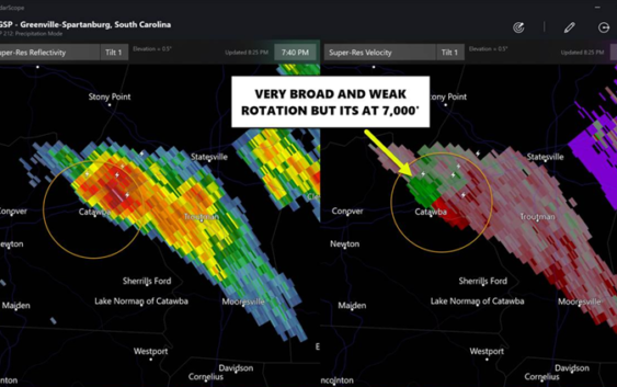
Saturday night’s tornado warning for Catawba, Iredell and Lincoln counties was an odd little storm. I can only assume we saw some kind of gustnado as it collided with an outflow boundary. The atmosphere was not really conducive for tornadoes, but these collisions can do weird things.
The storm was moving almost due South, which was a little bit more South than the other storms Saturday. It was very isolated as were all the storms Saturday. There was for one scan of the radar a couplet that showed broad rotation at 7:41 pm. It didn’t last long almost as soon as we saw it went away.

Brad Panovich
The storm didn’t exhibit anything you normally see in a tornadic storm and thus likely did not produce a tornado.
We did get one report of a funnel cloud around 8 p.m., though after looking at picture and video it might have been scud clouds. These are low clouds that can move along in the outflow, and sometimes when a storm collides with another outflow boundary, a quick spin can occur.
We call these gustnados because they form on the gusts front and spin quickly then go away.
Even when conditions are not favorable sometimes, two storms can make their own localized environment to spin up a funnel cloud.