- Dozens injured and at least five confirmed dead — including children — after reported tornado in North Texas
- Dozens injured and at least five confirmed dead — including children — after reported tornado Saturday night, Cooke County Sheriff says
- Dozens injured and at least five confirmed dead — including children — after reported tornado Saturday night, North Texas sheriff says
- Carolina Hurricanes General Manager Resigns
- North Carolina to provide state-relief funds for Gaston Co. storm damage victims
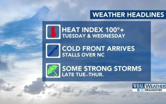
Chance for severe weather continues into Tuesday night
Raleigh, N.C. — A host of weather warnings have been issued as storms march through the Triangle and central North Carolina.
The National Weather Service has issued severe thunderstorm watches that include Durham, Wake, Orange and many other counties in the viewing area until 9 p.m. Severe thunderstorm warnings — meaning storms are in the area — have popped up several times during Tuesday. For a complete list of advisories issued by the National Weather Service, click here
WRAL meteorologist Aimee Wilmoth said the storms could bring torrential downpours, hail, lightning and the possibility of isolated tornadoes.
“The storms are moving to the east at about 20 miles per hour,” she said, adding that wind gusts could reach up to 65 miles per hour.
The Triangle is under a Level 2 threat for severe weather, and damaging winds, large hail and heavy rain are possible. Areas north of the Virginia border were under a level 3 risk for severe weather Tuesday, and storms began there after 3 p.m.
At Raleigh-Durham International Airport, there are some flight delays being reported. Duke Energy was reporting a number of power outages all across the state.
According to Wilmoth, storms will linger in the Triangle and viewing area until early Wednesday.

It was a hot one at many areas around North Carolina as heat indexes reached triple digits. That is likely to extend into Wednesday if we don’t receive rain again to cool the atmosphere. While Tuesday’s high was 95 degrees, the humidity levels made it feel as hot as 105 degrees outdoors.

Wednesday has a 60 percent chance of rain, and by Thursday evening the Triangle could see more than half an inch of rain.
Wednesday’s high will be in the lower 90s before highs stay in the upper 80s the rest of the week.
