- Severe weather leads to fallen trees, car crashes and flooding around the Triangle
- New video shows vehicles being swept away in historic, deadly flash floods in SA on June 12
- $40 million to go to underserved SC counties for Hurricane Helene recovery. Here's what you need to know.
- Family honors Air Force veteran Derwin Anderson Jr. after he died in June flash floods
- City of Wilmington addresses flooding on New Centre Drive
Severe weather possible Tuesday evening for Raleigh, Durham, surrounding areas
RALEIGH (WTVD) — Severe weather could develop Tuesday afternoon and evening throughout central North Carolina.
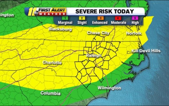
Most of the ABC11 viewing area is under a slight risk for severe weather.
Meteorologist Don “Big Weather” Schwenneker said the biggest threat from these storms are damaging winds, but there is an isolated chance of tornadoes as well.
Click here for First Alert Doppler Radar
Severe Risk in Category 3 of 5 (Enhanced) for southern Virginia. Cat 2 over most of our area otherwise. Biggest threat from damaging winds. Isolated chance of a tornado too. We will be watching throughout the day.#ncwx #vawx pic.twitter.com/DjfLIssiw3
— Don Schwenneker (@BigweatherABC11) August 13, 2019
Temperatures will reach into the mid-90s with a heat index above 100 in some places.
As the day progresses, storm activity will bring heavy downpours to parts of the viewing area by late afternoon and early evening. ABC11 will continue to keep you updated with the latest conditions here, on social media and on television.
Get weather on the ABC11 News app.
Wednesday will see highs in the low 90s with spotty showers and storms. The southeast area of central North Carolina will likely be under a marginal risk for severe weather.
Heat and humidity will continue to increase ahead of a surface low over Illinois. As this system slowly progresses eastward, rain can be expected through the weekend as the surface low stalls along the Carolina coast.
On Wednesday the cold front arrives to North Carolina and could bring the threat for heavy rainfall and flash flooding as PWAT values soar to 2.4 inches or above in some spots across the viewing area in the afternoon.
By Thursday, the cold front has moved through the viewing area and it will dry out the mid- and upper levels. This should suppress thunderstorm activity, but the surface feature will stall along the North Carolina coast. Storms will be isolated in nature across the viewing area with the threat not going away come the weekend and early next week.
Click here for the latest weather forecast.
Shower and thunderstorm activity will likely continue to be possible in spots of the viewing area come early next week as the surface low continues to hang out above the Outer Banks. The European model has this feature sliding northward into Delaware on Wednesday of next week, which may provide a break from shower activity.
Copyright © 2019 WTVD-TV. All Rights Reserved.