- Small plane bound for Jamaica with hurricane relief supplies crashes in Florida neighborhood
- Ask the Meteorologist: Did a tornado hit Johnston County Saturday night?
- Demolition begins on flood-damaged homes in Stoney Creek as neighbors await relief
- NC Office of State Fire Marshal aiding in Hurricane Melissa relief efforts
- U.S.-based aid groups rush to get supplies into storm-battered Jamaica after Hurricane Melissa
Severe weather moving into Triangle late afternoon could bring heavy rain, lightning
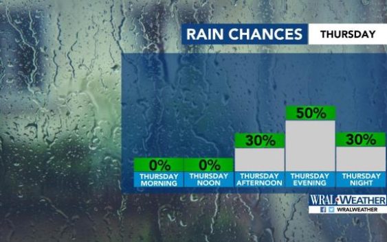
Raleigh, N.C. — The entire viewing area and most of the state is under a level 1 threat for severe weather for Thursday.
While the early afternoon should be quiet, storms are expected to move into central North Carolina late afternoon and stick around through midnight, according to WRAL meteorologist Elizabeth Gardner.
“Some of these storms may be on the stronger side,” Gardner said. “Damaging winds, heavy rain, hail and frequent lightning are possible.”
Download the WRAL Weather App to get severe weather alerts.

Despite the incoming storms, Thursday afternoon will be hot, with a high around 93 degrees.
Most of central North Carolina will be under a level 1 threat for severe weather on Friday, too, as another front approaches from the south.
Those storms will move in late afternoon or early evening Friday.
“It looks like a rainy evening,” Gardner said. “It is not looking good.”
Friday’s high will be 89 degrees.
Showers will linger Saturday, but high temperatures drop to the low 80s.
A break in the rain should come Sunday.
