- Houston Cougars take on A&M Aggies in charity exhibition game supporting Hurricane Beryl relief
- Hurricane Helene donations delivered to Avery County for Share the Warmth campaign
- Old Crow Medicine Show founder talks music, hurricane relief and this weekend's big benefit show
- IV fluid shortage caused by hurricane to last for months
- 'It financially annihilated us': Pregnant mother displaced for 2nd time after western NC floods
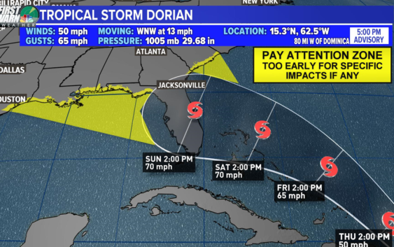
Could Tropical Storm Dorian impact the Southeast on Labor Day?
CHARLOTTE, N.C. — WCNC NBC Charlotte First Warn Chief Meteorologist Brad Panovich will be answering your questions about Tropical Storm Dorian, Tropical Depression Six, your Labor Day weekend forecast, and more in a live stream tonight. We will send a push notification to the WCNC news app when it starts.
Tropical Storm Dorian is headed towards Puerto Rico and could reach the southeastern portion of the United States by Labor Day – – if it can hold together.
Tropical Storm Dorian moved over Barbados and St. Lucia overnight Monday and early Tuesday, weakening a bit due to its interaction with the mountains of the islands. Later Tuesday, its track shifted northward as it continues towards Puerto Rico.
Maximum sustained winds are at 50 mph with stronger gusts. It would need winds of at least 74 mph to become a hurricane.
The official forecast from the National Weather Service keeps Dorian as a tropical storm. Very dry air and wind shear ahead is expected to make storm strengthening difficult. The storm will also have to battle the mountains of eastern Dominican Republic.
If it holds together, it could move over the Bahama and towards the coast of Florida over the long Labor Day weekend – – but it’s still early to know exactly where it will go and how strong it will be when it gets there.
This many days out, the forecast has a wide level of uncertainly. First Warn Chief Meteorologist Brad Panovich advises anyone from South Carolina through Florida and on to Texas to “pay attention” and keep monitoring the forecast.
On the current forecast track, the center of Dorian will move across the northeastern Caribbean Sea on Tuesday night pass over or near western and central Puerto Rico on Wednesday, and move near or just east of eastern Hispanola on Wednesday night.
Tropical Depression Six
Tropical Depression Six remains well off the Atlantic coast and away from land. It poses no threat to the mainland United States.
As of 5 pm Tuesday, it was centered about 410 west of Bermuda or about 315 miles southeast of Cape Hatteras and moving north-northwest at 7 mph. Maximum sustained winds remain at 35 mph.
According to the National Hurricane Center, some strengthening is occurring. It is expected to become a tropical storm on Wednesday, taking on the name Erin. However, it should begin to take on extratropical characteristics and weaken on Thursday as it moves away from land.
RELATED: FORECAST: Cloudy with a few showers overnight
RELATED: Person struck by lightning in Marion, numerous tress toppled during storms
RELATED: Lightning strikes kill 5, injure over 100 in eastern Europe’s Tatra Mountains
RELATED: Extensive tree damage in Statesville after severe weather
RELATED: Two rescued from flooded car during Charlotte storms