- Houston Cougars take on A&M Aggies in charity exhibition game supporting Hurricane Beryl relief
- Hurricane Helene donations delivered to Avery County for Share the Warmth campaign
- Old Crow Medicine Show founder talks music, hurricane relief and this weekend's big benefit show
- IV fluid shortage caused by hurricane to last for months
- 'It financially annihilated us': Pregnant mother displaced for 2nd time after western NC floods
Tropical Storm Dorian: Hurricane watch for Puerto Rico, Dominican Republic
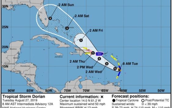
A hurricane watch has been issued for Puerto Rico and the Dominican Republic, but it’s unclear if Tropical Storm Dorian will be able to muster the 74-mph winds needed to reach Category 1 status.
The National Hurricane Center’s forecast as of 8 a.m. Eastern on Tuesday keeps Dorian a 70-mph tropical storm as it approaches the islands on a path that threads it through Puerto Rico and Hispaniola toward Florida.
Nearly the entire Florida Peninsula is in the hurricane center’s 5-day forecast cone, which has the center of the system between Freeport in the Bahamas and Hobe Sound at 2 a.m. Sunday.
Cities including St. Augustine through the Keys on the east coast and Homosassa Springs through Everglades City on the west coast are in the forecast cone.
The National Weather Service in Miami is issuing a special 8:30 forecast this morning ahead of Dorian.
Tropical Storm #Dorian is moving through the Windward Islands. Here are the 5 am AST Key Messages. pic.twitter.com/UKTuhBZnLP
— National Hurricane Center (@NHC_Atlantic) August 27, 2019
Dorian is forecast to be a high-end tropical storm with 70 mph winds as it approaches the Florida coast.
There is a between a 30 percent and 40 percent chance that coastal Palm Beach County could begin feeling tropical storm force winds late Friday in to Saturday morning.
“There is a real opportunity that this could have a major impact on Florida this weekend,” said Dan Kottlowski, senior hurricane forecaster at AccuWeather. “It could just be an overgrown tropical wave by then, but we really don’t know for sure at this point.”
At 8 a.m., Dorian was about 15 miles west-northwest of St. Lucia with maximum sustained winds of 50 mph. It is moving west-northwest at 13 mph.
RELATED: Hurricane season 2019: Everything you need to know
NHC hurricane specialist John Cangialosi said in the 5 a.m. forecast that conditions for Dorian to intensify improve north of Hispaniola and Puerto Rico. But it’s still unclear how much interaction there will be between Dorian and Hispaniola’s mountain ranges, which, at higher than 10,000 feet, can shred systems as they pass.
While the average 5-day track error is 500 miles, hurricane center forecasters said Florida residents should keep an eye on Dorian and “ensure their hurricane plan is in place.”
“Especially given the upcoming Labor Day weekend, we will need to keep a close eye on Dorian’s evolution,” said Weather Underground meteorologist Bob Henson in his Cat 6 column.
Kmiller@pbpost.com
@Kmillerweather