- Mosquito activity on the rise due to rainfall, flooding across Texas
- Volunteers help Conroe community clean up in wake of flooding in Montgomery County
- Why leaders are urging NC residents to start hurricane prep now
- Storms could produce hail, damaging winds south of Charlotte
- Large hail and strong winds cause damage in San Marcos and the Hill Country
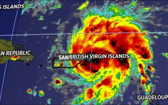
Dorian now a Hurricane near St. Thomas, forecast to target Southeast United States

CHARLOTTE, N.C. — Here’s the latest on Hurricane Dorian
As of the 2 p.m. et update from the National Hurricane Center
LOCATION: OVER ST. THOMAS
CATEGORY: ONE
MAXIMUM SUSTAINED WINDS…75 MPH
MOVEMENT…NW AT 13 MPH
Dorian is now a hurricane as it continues to strengthen and make its way toward the Virgin Islands.
Dorian is becoming a lot more organized and will continue to intensify over the next few days, according to WCNC NBC Charlotte First Warn Meterologist Chris Malcachy.
The 2 p.m. advisory from the National Hurricane Center showed the storm with 75 mph sustained winds and higher gusts of 90 mph. The storm is moving northwest at 13 mph and is right on top of St. Thomas.
Dorian is forecast to become a major Category 3 hurricane before making landfall on Florida’s Atlantic Coast, Mulcahy said. First Warn Chief Meteorologist Brad Panovich said Dorian is forecast to reach Florida with sustained winds of 115 mph.
Forecasters have now issued a hurricane warning for Vieques and Culebra, the U.S. Virgin Islands and the British Virgin Islands. A hurricane watch is in effect for parts of Puerto Rico, as well. Other parts of Puerto Rico are now under both a Hurricane Watch and a Tropical Storm Warning.
Tropical-storm-force winds are currently extending out up to 80 miles from Dorian’s center.
If it holds together, it could move over the Bahama and towards the coast of Florida over the long Labor Day weekend – – but it’s still early to know exactly where it will go and how strong it will be when it gets there.
This many days out, the forecast has a wide level of uncertainly. Panovich advises anyone from South Carolina through Florida and on to Texas to “pay attention” and keep monitoring the forecast.
Tropical Depression Erin
Tropical Storm Erin remains 190 miles off the coast of Cape Hatters, North Carolina.
The storm, which has sustained winds of 35 mph, is moving to the northwest at 13 mph. It is not expected to make a landfall in the United States.
Some strengthening is occurring, according to the National Hurricane Center. The storm could become what is defined as an “extra-tropical” storm as it moves toward Nova Scotia Thursday. An “extra-tropical” storm still contains the strength of a tropical system but inherits the title as it moves northward out of the tropics.
RELATED: Person struck by lightning in Marion, numerous tress toppled during storms
RELATED: Lightning strikes kill 5, injure over 100 in eastern Europe’s Tatra Mountains
RELATED: Extensive tree damage in Statesville after severe weather
RELATED: Two rescued from flooded car during Charlotte storms