- Trump makes more debunked claims about FEMA as he surveys storm damage in North Carolina
- Hundreds rescued, sheriff stranded on truck roof after deadly flooding in New Mexico
- In North Carolina, Trump and Harris navigate a hurricane and a rollercoaster governor’s race
- In North Carolina, Trump and Harris navigate a hurricane and a rollercoaster governor's race
- Family of Tennessee employee who died in Hurricane Helene flooding files wrongful death lawsuit
Tropical Storm Dorian One To Watch
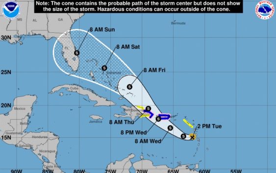
Tropical Storm Dorian, a rather tiny storm, has become the first real area of long-term tropical interest this season. Storms that have the ability to spend a fairly long time over the ocean (as opposed to Barry, earlier this year) make for interesting weather fodder and some jittery nerves for folks along the U.S. coastline. Dorian is one of those storms, though what happens to it over the next week as it inches closer to the east coast is difficult to predict.
At the moment, Dorian is moving northwesterly through the Caribbean where it should impact Puerto Rico and Hispaniola to some degree over the next couple days. After that, there are a lot of questions about where Dorian will ultimately wind up and just how powerful it might be.
The intensity forecast for Dorian is rather complicated. Small storms like this tend to be more easily disrupted by things like interaction with land or wind shear. Thus far, it has managed to fend off most of the dry air that has been trying to invade it, but it isn’t exactly the healthiest picture of a storm we’ve ever seen.
That could change as it moves out of what can be a death zone for hurricanes, particularly the mountains of Hispaniola. Once it gets north and east of that area approaching the Bahamas, there is a lot of warm water waiting for it, giving it plenty of opportunity to intensify.
But, we are still at least three day from Dorian reaching the Bahamas and five or six days from it potentially impacting the coast of Florida, so there is still a great deal of uncertainty surrounding its intensity forecast.
As for where it will go, there was a small shift to the north on Tuesday after a hurricane hunter plane determined the center of the storm was farther north than originally thought. Now, forecasters believe the storm could move even east of the Bahamas before making a more west-northwesterly turn this weekend.
The latest forecast model runs suggest that the final landfall for Dorian could be somewhere along the east-central coast of Florida with an intensity of anything from a depression to a category one hurricane. One model suggests the storm will make it across the peninsula and reemerge in the Gulf of Mexico before a second landfall in the Florida panhandle.
That is between five and eight days away and uncertainty beyond three days remains extremely high both for the forecast track and intensity.
There doesn’t appear to be an imminent threat to Texas at this point, either from Dorian or any other tropical disturbance, but given that we are about two weeks from the statistical peak of hurricane season, every storm bears watching.