- Houston Cougars take on A&M Aggies in charity exhibition game supporting Hurricane Beryl relief
- Hurricane Helene donations delivered to Avery County for Share the Warmth campaign
- Old Crow Medicine Show founder talks music, hurricane relief and this weekend's big benefit show
- IV fluid shortage caused by hurricane to last for months
- 'It financially annihilated us': Pregnant mother displaced for 2nd time after western NC floods
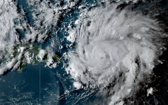
Hurricane Dorian expected to strengthen into a major hurricane
CHARLOTTE, N.C. — Here’s the latest on Hurricane Dorian
As of the 5 a.m. et update from the National Hurricane Center
LOCATION: 150 MILES NNW OF SAN JUAN PUERTO RICO
CATEGORY: ONE
MAXIMUM SUSTAINED WINDS: 85 MPH
MOVEMENT: NW AT 13 MPH
Dorian is a Category one hurricane with sustained winds of 85 mph but is forecasted to strengthen into a major hurricane within the next few days, the National Hurricane Center predicts.
The storm is moving toward the northwest at 13 mph and is expected to move in that direction through Friday. There are no coastal watches or warnings in effect.
On this track, Dorian should move over the Atlantic well east of the southeastern and central Bahamas on Thursday and Friday.
Dorian is expected to produce the following rainfall accumulations:
- Northern Leeward Islands: 1 to 3 inches
- Central and northwestern Bahamas: 2 to 4 inches, isolated 6 inches
- Coastal sections of the Southeast United States: 4 to 8 inches, isolated 10 inches.
The rainfall may cause life-threatening flash floods. Swells around the U.S. and British Virgin Islands and Puerto Rico should gradually diminish Wednesday night.
Dorian is forecast to strengthen into a powerful hurricane during the next few days. Hurricane-force winds extend outward up to 15 miles from the center, and tropical-storm-force winds extend outward up to 70 miles.
Dorian is becoming a lot more organized and will continue to intensify, according to First Warn Chief Meteorologist Brad Panovich.
By Thursday, the storm is expected to continue northwest into open water, where it will feed off of warmer waters and continue to strengthen.
As it passes to the north of the Bahamas, it is expected to strengthen into a Category 3 storm, which would make it a “major hurricane” with sustained winds of at least 111 mph.
There remains uncertainty in the forecast this many days out – – but the best indication is the storm will make landfall along Florida’s eastern coast or coastal Georgia early next week. The uncertainty, which is commonly portrayed in the forecast track’s “cone of uncertainty,” will shrink as the storm moves closer to shore.
RELATED: 5 Things to Know About Hurricane Dorian
Panovich said everyone living along the Southeast coast should be paying attention. The track could shift.
“Residents in these areas should ensure that they have their hurricane plan in place and not focus on the exact forecast track of Dorian’s center,” according to the National Hurricane Center.
Regardless of where the storm ultimately makes landfall, heavy rain can be expected in portions of the Bahamas, Florida, Georgia, and South Carolina.
Residents leaving along the shore should also monitor dangerous storm surge and rip currents, which are also a threat along coastal North Carolina because of Tropical Depression Erin.
Current Hurricane Dorian warnings
There are no coastal watches or warning in effect.
RELATED: Airlines offer travel waivers as Dorian reaches hurricane strength
Tropical Depression Erin
Tropical Storm Erin remains 190 miles off the coast of Cape Hatters, North Carolina.
The storm, which has sustained winds of 35 mph, is moving to the northwest at 13 mph. It is not expected to make a landfall in the United States.
Some strengthening is occurring, according to the National Hurricane Center. The storm could become what is defined as an “extra-tropical” storm as it moves toward Nova Scotia Thursday. An “extra-tropical” storm still contains the strength of a tropical system but inherits the title as it moves northward out of the tropics.
RELATED: Person struck by lightning in Marion, numerous tress toppled during storms
RELATED: Lightning strikes kill 5, injure over 100 in eastern Europe’s Tatra Mountains
RELATED: Extensive tree damage in Statesville after severe weather
RELATED: Two rescued from flooded car during Charlotte storms