- Mosquito activity on the rise due to rainfall, flooding across Texas
- Volunteers help Conroe community clean up in wake of flooding in Montgomery County
- Why leaders are urging NC residents to start hurricane prep now
- Storms could produce hail, damaging winds south of Charlotte
- Large hail and strong winds cause damage in San Marcos and the Hill Country
Latest track shows Hurricane Dorian as strong Category 3 storm off NC's coast later this week

Raleigh, N.C. — Dorian, still a life-threatening Category 5 hurricane, is expected to sit over the Bahamas on Monday before making its way closer to the United States. Dorian is already creating strong rip currents off North Carolina’s coast, but it shouldn’t impact our state until Wednesday night or Thursday.
A 5 a.m. updated forecast track from the National Hurricane Center shows the storm approaching North Carolina’s southeast tip as a Category 3 hurricane later this week. Older predictions showed it to be much weaker by the time it nears our coast.
“This is not good news,” said WRAL meteorologist Aimee Wilmoth.
On Sunday, Dorian made landfall in the Bahamas. Maximum sustained winds reached 185 mph along with wind gusts up to 220 mph, tying the record for the most powerful Atlantic hurricane to ever make landfall. On Monday, a Bahamas news outlet reported at least one death and multiple reports of missing people.
Dorian is expected to turn to the north late Monday and should weaken to a Category 4 by that time. By Tuesday, models show Dorian moving north in the Atlantic, parallel to the coastline. Dorian could weaken to a Category 3 storm by Wednesday as it loses intensity.
By Wednesday night or Thursday, Dorian is expected to affect central North Carolina and the coast. At that time, it could impact South Carolina and North Carolina, dropping heavy rain along the the coast and bringing strong winds.
North Carolina timing
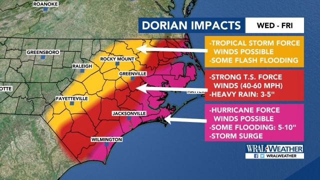
Hurricane Dorian is expected to brush North Carolina’s southeast tip as a Category 3 hurricane. Even if Dorian doesn’t make landfall on North Carolina’s coast, effects like strong winds and heavy rains will be felt Wednesday through Thursday, with the strongest impacts Thursday night and Friday morning.
On Friday, the storm is expected to turn and move out to sea.
A few lines in a scatter model indicate that Dorian could make landfall in North Carolina, while most tracks show the storm moving off into the Atlantic Ocean.
The coast and the Triangle are both within the storm’s cone, meaning landfall is still possible there. “Since the cone includes the coast, and Raleigh, we have to keep a close eye on this,” WRAL meteorologist Peta Sheerwood said.
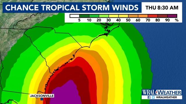
Depending on the storm’s path, central North Carolina could see tropical storm force winds around 45 or 50 mph by 2 p.m. Thursday. North Carolina’s coast could experience even stronger winds of 70 to 90 mph.
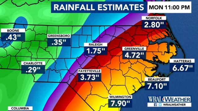
Sheerwood said rainfall totals “look impressive,” with some coastal areas expected to get as much as 10 inches. Raleigh could get up to 1.75 inches of rain, while Wilmington and Beaufort could get almost 8 inches. Officials were North Carolina and South Carolina are already asking beachgoers to stay out of the ocean,Monday as Dorian is kicking up rip currents there.
Preparations underway
From Florida to North Carolina, residents and government officials have been preparing for possible impacts of Dorian for days, even as the official forecast has the center of the storm staying offshore.
The Category 5 hurricane’s nearly unprecedented strength has people aware that even a tiny error in the forecast could be catastrophic.
“We may not do anything. But we have to be ready for it,” said Neil Baxley, commander of emergency services in coastal South Carolina’s Beaufort County. “We are deep in the error cone.”‘
The gas lines and people queued up with carts outside grocery stores weren’t seen Sunday along the southeast U.S. coast.
Instead, people were watching and waiting to see the destruction from the northern Bahamas, where Dorian made landfall on the Abaco Islands.
“I’m thanking God now that it has turned a little more to the east. But that’s a forecast. We never know,” said Kevin Browning, who was at the Vero Beach Home Depot looking for supplies after putting up his hurricane shutters Friday. “I feel for the Bahamas and I’m praying for them.”
Some evacuations have already begun in Florida, where the governor suspended tolls. Father up the coast, South Carolina Gov. Henry McMaster held a short news conference where he wouldn’t say when he might make a decision on evacuations and the main goal seemed to be to promise officials were on top of things.
South Carolina has ordered evacuations in each of the past three hurricane seasons and with just one storm making landfall during that time — Michael in 2016 — there is storm weariness in the state.
McMaster asked residents to stay tuned.
“We don’t have a solid prediction as to where it might turn, where it might not turn when it will get here. But we assure you we have the best minds and the most experienced and talented people working around the clock,” the governor said.


