- EF-1 tornadoes ripped through Cypress, Waller County areas with winds at more than 100 mph, NWS reports
- Houston-area storm damage updates: Clean up continues after NWS says two EF-1 tornadoes and powerful derecho ripped through SE Texas
- Low risk of damaging winds, hail from Saturday storms
- EF 1 tornadoes ripped through Cypress, Waller County areas at more than 100 mph, NWS reports
- Caddo Mounds State Historic Site to celebrate new visitor center, traditional grass house after 2019 tornado
Hurricane Dorian finally begins to move away from Grand Bahama
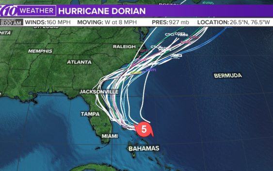
ST. PETERSBURG, Fla — Hurricane Dorian’s core is finally moving away from Grand Bahama, although dangerous winds and life-threatening storm surge will continue through this evening.
Dorian has been downgraded to a Category 2 storm with sustained winds of 110 mph. As of the latest National Hurricane Center update, Dorian was located about 105 miles east of Fort Pierce, Florida. It’s moving to the northwest at 5 mph.
People living in parts of the northern Bahamas have been dealing with hours of nonstop storm surge up to roofs and strong winds.
The government of the Bahamas has changed the hurricane warning to a tropical storm warning for Grand Bahama and the Abacos Islands.
Dorian first made landfall in Elbow Cay, Bahamas, around 12:45 p.m. Sunday with maximum sustained winds of 185 mph as a Category 5 hurricane. Hurricane Dorian’s falling wind speeds since then made it a Category 4 storm Monday morning. From there, it weakened further.
However, Dorian remains an extremely destructive storm.
The most reliable weather computer models have been consistent in keeping the powerful storm just off the Florida coast and away from landfall. These models, however, are not forecasts — and they tend to change with every update.
In fact, some models include parts of Florida’s east coast for significant impacts or a potential landfall.
LIVE BLOG: The latest, need-to-know information on Hurricane Dorian
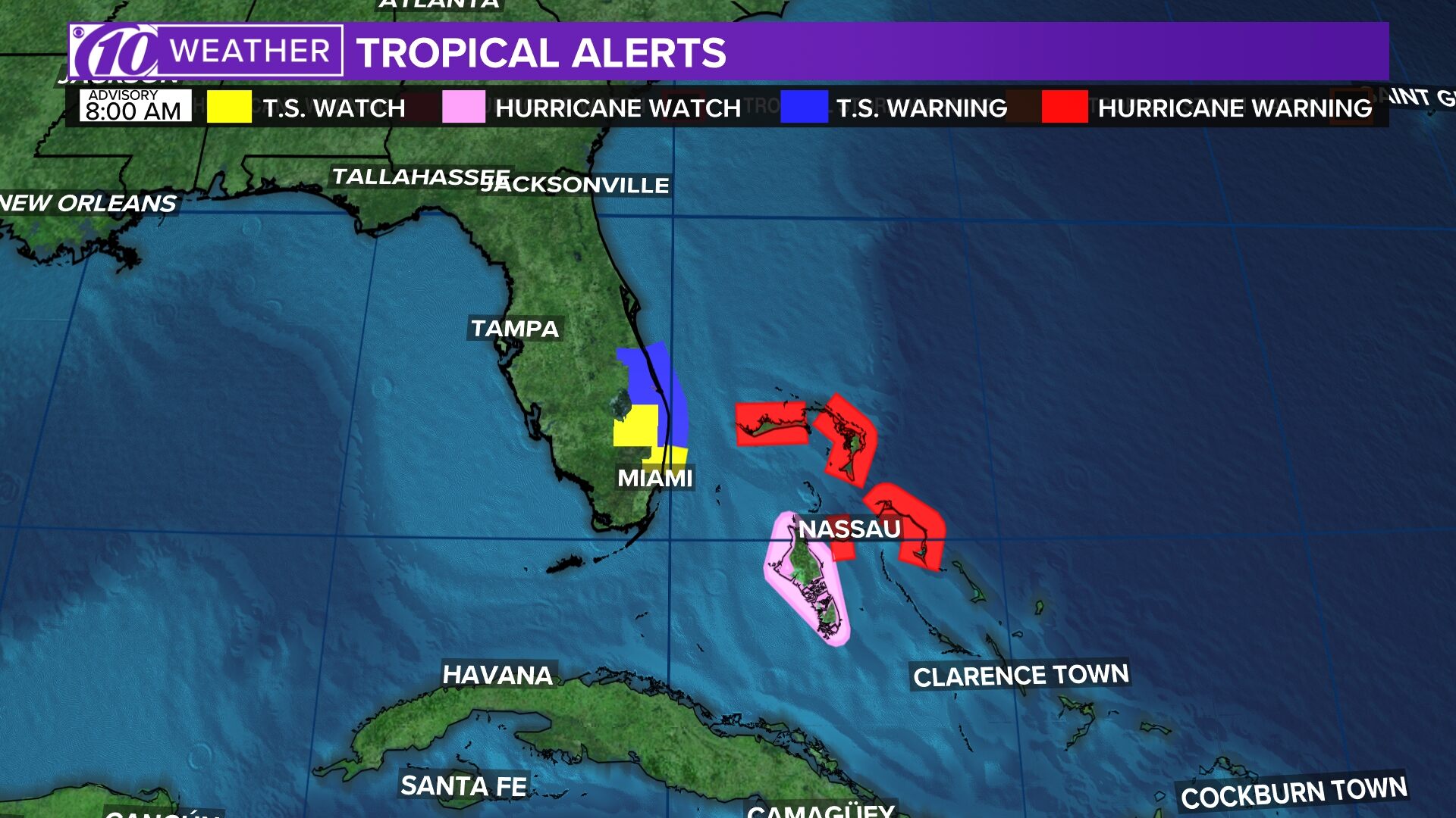
The following watches and warnings are in effect:
- Hurricane warning: Jupiter Inlet to Ponte Vedra Beach, Florida; North of Edisto Beach, South Carolina to South Santee River
- Hurricane watch: North of Ponte Vedra Beach, Florida to Edisto Beach, South Carolina; North of South Santee River, South Carolina to Duck, North Carolina; Albemarle and Pamlico Sounds
- Tropical storm warning: Grand Bahama and the Abacos Islands in the northwestern Bahamas; North of Deerfield Beach to Jupiter Inlet, north of Ponte Vedra Beach to Edisto Beach, South Carolina
- Storm surge warning: Jupiter Inlet, Florida to South Santee River, South Carolina
- Storm surge watch: North of South Santee River, South Carolina to Cape Lookout, North Carolina
RELATED: What’s the difference between a hurricane watch and a warning?
The National Hurricane Center said hazards for the islands include powerful wind gusts and storm surge 12-18 feet above normal tide levels, with possibly higher waves.
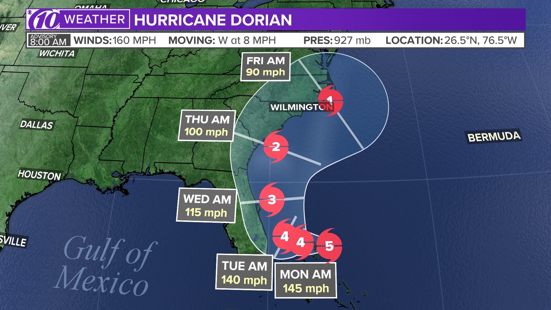
Dorian’s apparent turn northwest is a positive forecast for the Tampa Bay region but one of most concern for Florida’s east coast because a slow, powerful storm that rides the coastline is likely to bring more prolonged and significant impacts. Florida is technically out of the cone of uncertainty in the latest hurricane track, but that definitely doesn’t mean the coast is out of the woods. And, people should continue to brace for the storm.
Again, stay tuned to the latest forecast as Dorian’s track and intensity become more certain.
►Track the weather and get severe alerts when they happen: Download the 10 News app now.
►Stay informed with all tropical weather: Check out our must-have interactive Hurricane Headquarters guide here.
Spaghetti models
Each line represents a computer model’s best “guess” of where the center of the storm will go. Together, they look like spaghetti noodles. Remember, impacts from a tropical system can and do occur miles away from the center.
App users — tap here if you cannot see the image below.
Tropical track
This is the latest “cone of uncertainty,” which shows an area where the center of the storm could go, when and how strong it might be at the given time.
App users — tap here if you cannot see the image below.
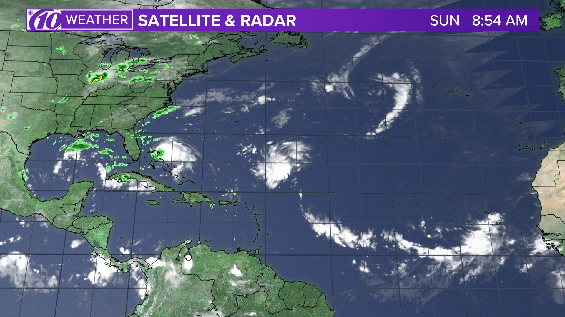
Satellite and radar
The latest satellite and radar image for the Gulf of Mexico, Caribbean Sea and Atlantic Ocean.
App users — tap here if you cannot see the image below.
Watches and warnings
What’s a watch? What’s a warning? Here are the official alerts that can be issued for your area and what you should do.
App users — tap here if you cannot see the image below.