- Rock Hill storm damage costs are 'somewhere around $5 million.' That number doesn't include damage to personal property
- Rock Hill storm damage costs are 'somewhere around $5 million.' That number doesn't include damage to personal property
- ‘Somewhere around $5 million’ | Rock Hill officials see major storm damage costs
- The deadliest tornadoes to ever hit Austin
- Whiteville resident recalls events from Tuesday nights tornado
9 a.m. update: Dorian creates tornadoes as it pounds Carolina coast
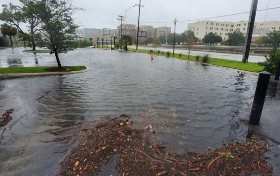
CHARLOTTE, N.C. — The Carolinas are feeling the brunt of Hurricane Dorian’s fury as the storm has produced multiple tornadoes, downed trees and caused widespread flooding along the coastline.
As of 9 a.m., Dorian, which is still a Category 3 hurricane with 115 mph winds, is now moving north-northeast as it sits about 70 miles southeast of Charleston, South Carolina. The National Hurricane Center said Dorian has continued to create tornadoes across northeastern South Carolina and southeast North Carolina.
First Warn forecaster Larry Sprinkle said some areas along the coast near Charleston could see nearly 9 feet of storm surge during high tide Thursday. That includes nearly a foot of rain from Dorian’s bands, which have been dumping water on the coast since Wednesday. Forecasters believe the storm is likely to make landfall somewhere in North Carolina late Thursday into Friday.
In Charleston County, South Carolina, the sheriff’s office reported downed trees and power lines, plus flooding closed some roads.
“Please do not leave your home unless your life is in danger there,” the sheriff’s office tweeted.
South Carolina Emergency Management reported 81,446 power outages related to the storm around 5 a.m. Thursday. That number is expected to grow as conditions get worse. The National Weather Service in Wilmington shared a video from Pender County where a tornado touched down near a fire department Thursday morning. There are multiple tornado warnings in effect in coastal areas as the outer bands of Dorian move across southeastern North Carolina.
The NOAA reported sustained winds of 60 mph with gusts of 95 mph about 10 miles south-southeast of Beaufort, South Carolina. A sustained wind of 71 mph was reported about 45 miles southeast of Charleston at 9 a.m.
First Warn chief meteorologist Brad Panovich says the storm will likely make landfall in eastern North Carolina sometime late Thursday or early Friday.
The powerful storm was parked over the Bahamas for over 24 hours before starting to crawl toward the northwest. Dorian was expected to stay offshore as it moved along the Florida coast. The storm was “lashing the east coast of Florida,” the National Hurricane Center said.
The storm was packing sustained of 115 mph with higher gusts. According to the National Hurricane Center, hurricane-force winds extended outward up to 60 miles from the center, while tropical-storm-force winds extended about 195 miles from Dorian’s center.
Panovich said the biggest concerns for the Carolinas will be along the coast with the combination of heavy rain, wind and storm surge. First Warn Forecaster Larry Sprinkle said the most dangerous part of a storm is the surge.
In Charlotte, Sprinkle said we’ll see minimal to no impact fro Dorian as it moves up the coast. Areas east of I-77 could see wind gusts around 30-40 mph, Sprinkle said. Those areas include Monroe, Matthews, Mint Hill, Albemarle and toward Rockingham and Wadesboro.
WCNC has a new app. Click here to download it
Hurricane Dorian latest conditions
As of the 9 a.m. ET advisory from the National Hurricane Center
LOCATION: ABOUT 70 MILES SOUTHEAST OF CHARLESTON, SC
MAXIMUM SUSTAINED WINDS: 115 MPH
MOVEMENT: NORTH-NORTHEAST AT 8 MPH
Panovich said confidence in the models means forecasters can be more focused on the impacts when the storm does eventually reach the Carolina coast.
The high risk along the coast could result in 5-10 feet of storm surge, 10-15 inches of rain, and 50-75 mph winds as the storm churns north.
There is some good news for those that are inland, as Panovich said Dorian won’t be a major wind event. The impacts will be spread further out, but the highest impact will be on the immediate coast.
Panovich said the storm will cause sound-side flooding when it reaches the Outer Banks and affect areas that were devastated by Hurricane Florence, such as New Bern and Havelock.
Never miss an alert. Download the new WCNC app today
Forecast timing
The storm will move north up the coast and reach Myrtle Beach by Thursday night into Friday. Dorian was expected to reach the Outer Banks Friday morning, with a possible landfall coming near Hatteras as some of the models start to disagree on the storm’s exact track.
On Sunday evening, South Carolina Gov. Henry McMaster issued mandatory evacuations for people living along the coastline of South Carolina. State troopers began the reversal of all lanes on I-26 out of Charleston Monday morning with evacuations taking effect at 12 p.m.
“Water, water, water is our concern,” said Panovich, urging anyone told to evacuate to listen. “You run from the water; you hide from the wind.”
RELATED: Mandatory evacuations ordered for entire South Carolina coast, lane reversals for I-26
North Carolina issued a state of emergency ahead of potential impacts from Hurricane Dorian. South Carolina Governor Henry McMaster also declared a state of emergency because of the storm threat.
On Saturday, the city of Charleston declared a state of emergency as well to ensure the city was fully prepared for emergency operations. The Municipal Emergency Operations Center activated Sunday at 8 a.m. and will remain open as needed throughout the storm.
According to the National Weather Service, there was an increasing risk of strong winds and dangerous storm surge along the coasts of Georgia, South Carolina and North Carolina during the middle of the week.
INTERACTIVE MAP: Track Hurricane Dorian
Watches and warnings
A Storm Surge Warning is in effect for…
* Savannah River to Poquoson VA
* Pamlico and Albemarle Sounds
* Neuse and Pamlico Rivers
* Hampton Roads
A Hurricane Warning is in effect for…
* North of Savannah River to the North Carolina/Virginia border
* Pamlico and Albemarle Sounds
A Tropical Storm Warning is in effect for…
* North Carolina/Virginia border to Chincoteague VA
* Chesapeake Bay from Smith Point southward
A Tropical Storm Watch is in effect for…
* North of Chincoteague VA to Fenwick Island DE
* Chesapeake Bay from Smith Point to Drum Point
* Tidal Potomac south of Cobb Island
*Woods Hole to Sagamore Beach MA
*Nantucket and Martha’s Vineyard MA
RELATED: 5 Things to Know About Hurricane Dorian
“Residents in these areas should ensure that they have their hurricane plan in place and not focus on the exact forecast track of Dorian’s center,” according to the National Hurricane Center.
RELATED: Airlines offer travel waivers as Dorian reaches hurricane strength
RELATED: Person struck by lightning in Marion, numerous tress toppled during storms
RELATED: Lightning strikes kill 5, injure over 100 in eastern Europe’s Tatra Mountains
RELATED: Extensive tree damage in Statesville after severe weather
RELATED: Two rescued from flooded car during Charlotte storms