- Rock Hill storm damage costs are 'somewhere around $5 million.' That number doesn't include damage to personal property
- Rock Hill storm damage costs are 'somewhere around $5 million.' That number doesn't include damage to personal property
- ‘Somewhere around $5 million’ | Rock Hill officials see major storm damage costs
- The deadliest tornadoes to ever hit Austin
- Whiteville resident recalls events from Tuesday nights tornado
Hurricane Dorian is crawling up the east coast, staying just offshore
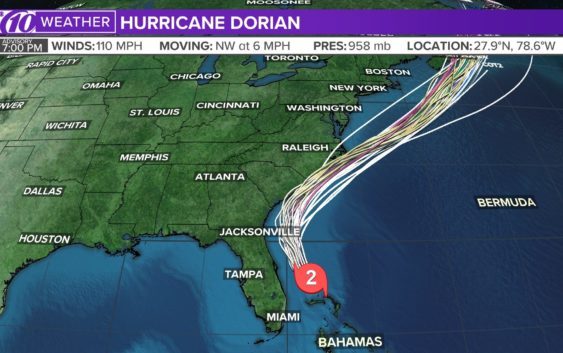
ST. PETERSBURG, Fla — Hurricane Dorian’s wind speeds remain at 110 mph as it continues to move parallel to the east coast at 8 mph. The Category 2 storm is currently about 115 miles south-southwest of Wilmington, N.C. as of 2 p.m. Thursday.
The tropical storm warning has been extended north to Fenwick Island, Delaware and also north in the Chesapeake Bay to Drum Point, including the Tidal Potomac River south fo Cobb Island.
The storm is being blamed for at least 20 deaths in the Bahamas.
Hundreds of shelter animals from coastal South Carolina have arrived in Delaware ahead of Hurricane Dorian’s expected landfall.
The News Journal of Wilmington reports the animals were moved from shelters at risk of flooding. The Category 3 storm began making its way across the Carolinas Thursday and was expected to flood low-lying areas and bring enough rain to cause flash flooding concerns well inland.
Nearly 200 animals were airlifted off the endangered coast and picked up by Brandywine Valley SPCA early Tuesday. About 150 other animals were expected to arrive that night via land transport from Best Friends Animal Society. The animals may be up for adoption throughout New England later this week.
Brandywine says the lessened South Carolina shelter populations will make space for local pets impacted by Dorian.
LIVE BLOG: The latest, need-to-know information on Hurricane Dorian
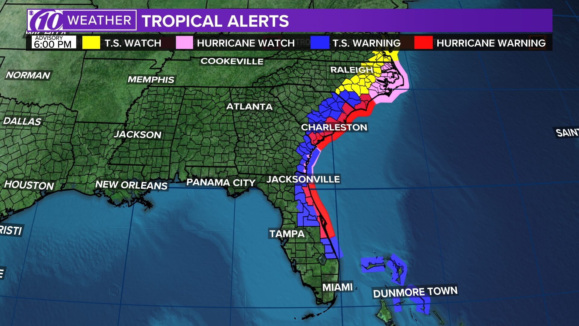
Current hurricane watches and warnings include:
Storm Surge Warning:
- South Santee River, SC to Poquoson, VA
- Pamlico and Albemarle Sounds
- Neuse and Pamlico Rivers
- Hampton Roads
Hurricane Warning:
- Savannah River to the North Carolina/Virginia border
- Pamlico and Albemarle Sounds
Tropical Storm Warning:
- North Carolina/Virginia border to Fenwick Island, DE
- Chesapeake Bay from Drum Point southward
- Tidal Potomac south of Cobb Island
Tropical Storm Watch:
- Woods Hole to Sagamore Beach, MA
- Nantucket and Martha’s Vineyard, MA
RELATED: What’s the difference between a hurricane watch and a warning?
Dorian first made landfall in Elbow Cay, Bahamas, around 12:45 p.m. Sunday with maximum sustained winds of 185 mph as a Category 5 hurricane. Hurricane Dorian’s falling wind speeds since then made it a Category 4 storm Monday morning. From there, it weakened further.
However, Dorian remains an extremely destructive storm.
Stay tuned to the latest forecast as Dorian’s track and intensity become more certain.
►Track the weather and get severe alerts when they happen: Download the 10 News app now.
►Stay informed with all tropical weather: Check out our must-have interactive Hurricane Headquarters guide here.
Spaghetti models
Each line represents a computer model’s best “guess” of where the center of the storm will go. Together, they look like spaghetti noodles. Remember, impacts from a tropical system can and do occur miles away from the center.
App users — tap here if you cannot see the image below.
Tropical track
This is the latest “cone of uncertainty,” which shows an area where the center of the storm could go, when and how strong it might be at the given time.
App users — tap here if you cannot see the image below.
Watches and warnings
What’s a watch? What’s a warning? Here are the official alerts that can be issued for your area and what you should do.
App users — tap here if you cannot see the image below.