- How to protect your car before a hailstorm
- ‘We lost everything’: East Texas residents confront their future after flooding
- Here's how to get your flooding debris picked up by the City of Houston
- Mosquito activity on the rise due to rainfall, flooding across Texas
- Volunteers help Conroe community clean up in wake of flooding in Montgomery County
Tornado warning issued for Bladen County, watch for Johnston County as Hurricane Dorian nears NC coast
Things to know:
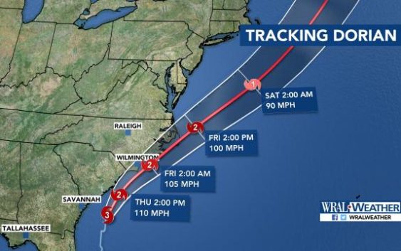
- Hurricane Dorian was a Category 3 hurricane early Thursday, and the eye of the storm is expected to move near or over the North Carolina coast as a Category 2.
- A tornado warning was issued for Bladen County until 8:15 a.m. A tornado watch was issued for Johnston, Nash, Wayne, Wilson, Duplin, Lenoir and Greene counties.
- Wake County and other eastern areas are under a tropical storm warning. See the full list of weather alerts.
- Wake, Durham and Johnston Public Schools are closed Thursday. View complete closings and delays.
7:25 a.m. — A tornado warning was issued for Bladen County until 8:15 a.m. A tornado watch was issued for Johnston, Nash, Wayne, Wilson, Duplin, Lenoir and Greene counties.
6:25 a.m. — Utility crews from across the country are staging in Raleigh so they can move in to start restoring power as soon as Hurricane Dorian leaves.
Hundreds of trucks were at Walnut Creek Amphitheater, ready to deploy to areas that lose power.
Duke Energy said 700,000 people could lose power as Hurricane Dorian moves up the North Carolina coast.
The utility company nearly doubled its fleet of linemen, adding 4,000 crew members from 23 states to handle issues from the storm.
Widespread outages are expected from the coast even to the Triangle.
6:20 a.m. — Conditions were calm in Dare County, with low surf and light winds, but “we shouldn’t be fooled by any of this,” WRAL reporter Adam Owens said.
Storm surge could be as high as 6 feet as the eye of Hurricane Dorian is expected to move near or over the North Carolina coast Thursday evening and into Friday.
Emergency officials say people need supplies to sustain themselves for 72 hours.
John Silver’s home has been standing since 1875, and it’s weathered many storms.
“We’ve always just pieced it back together,” Silver said. “Originally we would find driftwood on the beach and — my ancestors would, and then we would — piece it back together.”
The house has been moved back away from the sea as the years have gone on.
Silver said he thinks his house will fare well in Dorian, but emergency officials said people shouldn’t stick around to see.
Dare County was one of several states under a mandatory evacuation for both visitors and residents.
5 a.m. — Dorian is a Category 3 hurricane with sustained winds reaching 115 mph, the National Hurricane Center said Thursday morning. The storm’s center is expected to move near or over the North Carolina coast Thursday evening and overnight into Friday.
A tornado warning was issued for southeastern Brunswick County until 5:15 a.m. as the hurricane’s eye was 200 miles away from Wilmington. It was moving north at 8 mph.
The National Hurricane Center’s 5 a.m. forecast showed Dorian moving up the South Carolina and North Carolina coasts and turning northeast sometime Thursday.
“It’s certainly continuing to look like the storm is going to ride right up the coast of North Carolina, and if it bobbles inland, it shouldn’t be very much,” WRAL meteorologist Gardner said.
“Even if the storm stays well offshore, this is still going to be a very big deal for the coast of North Carolina,” she added.
A hurricane warning is in effect for the entire North Carolina coast, with sustained winds at 55 to 85 mph and gusts up to 110 mph.
The southern North Carolina coast could see 4 to 7 feet of storm surge. The central coast could see 4 to 6 feet of storm surge, and 2 to 4 feet of storm surge is expected along the northern coast.
East of Goldsboro, 6 to 12 inches of rainfall is expected.
A tropical storm warning is in effect from Raleigh to Greenville, with 30-40 mph winds and gusts between 40 and 60 mph expected.
The Triangle could see 1 to 3 inches of rain, and Fayetteville could see 4 to 6 inches of rain. Goldsboro could see 4 to 8 inches of rain.