- North Carolina behind on hurricane preparedness, study shows
- North Carolina way behind on hurricane preparedness, study shows
- New hurricane preparedness report doesn't rank North Carolina well
- New hurricane preparedness report doesn't rank North Carolina well
- Southport hosts annual Hurricane Expo ahead of the 2024 season
Hurricane Dorian moves away from mid-Atlantic

ST. PETERSBURG, Fla — The Canadian Hurricane Center is issuing warnings, as Hurricane Dorian continues to churn to the northeast.
Dorian is currently packing 90 mph winds, as it moves along at 21 mph. The latest data shows the eye about 125 miles northeast of Cape Hatteras, North Carolina.
A hurricane warning has now been issued for eastern Nova Scotia from Hubbards to Avonport. Additionally, Canadian forecasters have issued a hurricane watch for Prince Edward Island, southwestern Nova Scotia from Avonport to Hubbards, the Magdalen Islands and southwestern Newfoundland from Parson’s Pond to Indian Harbour.
Hurricane Dorian came ashore Friday at Cape Hatteras on North Carolina’s Outer Banks, marking its first U.S. landfall since it slammed into the Bahamas days ago.
Dorian sideswiped most of the Southeast seaboard from Florida to Carolinas in recent days before its eye made landfall Friday morning.
On Thursday, Dorian raked the Carolina coast with howling winds and heavy rain, spinning off tornadoes and knocking out power to more than 200,000 homes and businesses. The U.S. National Hurricane Center says Dorian is expected to accelerate as it moves off extreme southeastern New England sometime Friday night and early Saturday before a weekend approach to Nova Scotia in Canada.
The storm is being blamed for at 30 deaths.
LIVE BLOG: The latest, need-to-know information on Hurricane Dorian
Current hurricane watches and warnings include:
Storm Surge Warning:
- Salter Path, NC to Poquoson, VA
- Pamlico and Albemarle Sounds
- Neuse and Pamlico Rivers
- Hampton Roads
Hurricane Warning:
- Boque Inlet to the North Carolina/Virginia border
- Pamlico and Albemarle Sounds
- Eastern Nova Scotia from Hubbards to Avonport
Hurricane Watch:
- Southwestern Nova Scotia from Avonport to Hubbards
- Prince Edward Island
- Magdalen Islands
- Southwestern Newfoundland from Parson’s Pond to Indian Harbour
Tropical Storm Warning:
- North Carolina/Virginia border to Fenwick Island DE
- The Chesapeake Bay from Drum Point southward
- Tidal Potomac south of Cobb Island
- Woods Hole to Sagamore Beach MA
- Nantucket and Martha’s Vineyard MA
- East of Bar Harbor to Eastport, ME
Tropical Storm Watch:
- Prince Edward Island
- Magdalen Islands
- Fundy National Park to Shediac
- Francois to Boat Harbour
RELATED: What’s the difference between a hurricane watch and a warning?
Dorian first made landfall in Elbow Cay, Bahamas, around 12:45 p.m. Sunday with maximum sustained winds of 185 mph as a Category 5 hurricane.
Stay tuned to the latest forecast as Dorian’s track and intensity become more certain.
►Track the weather and get severe alerts when they happen: Download the 10 News app now.
►Stay informed with all tropical weather: Check out our must-have interactive Hurricane Headquarters guide here.
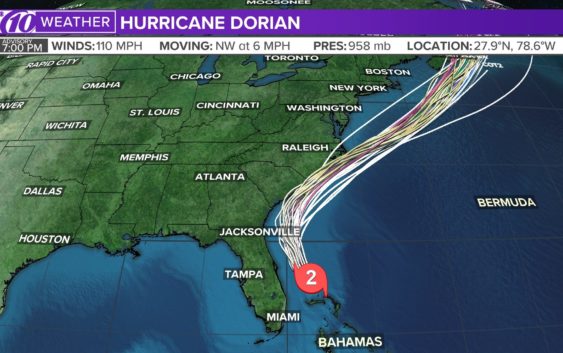
Spaghetti models
Each line represents a computer model’s best “guess” of where the center of the storm will go. Together, they look like spaghetti noodles. Remember, impacts from a tropical system can and do occur miles away from the center.
App users — tap here if you cannot see the image below.
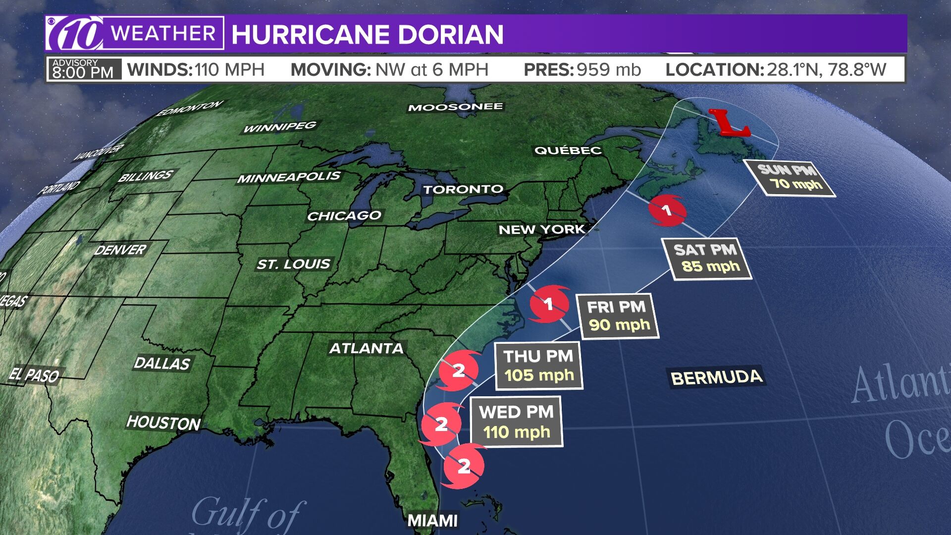
Tropical track
This is the latest “cone of uncertainty,” which shows an area where the center of the storm could go, when and how strong it might be at the given time.
App users — tap here if you cannot see the image below.

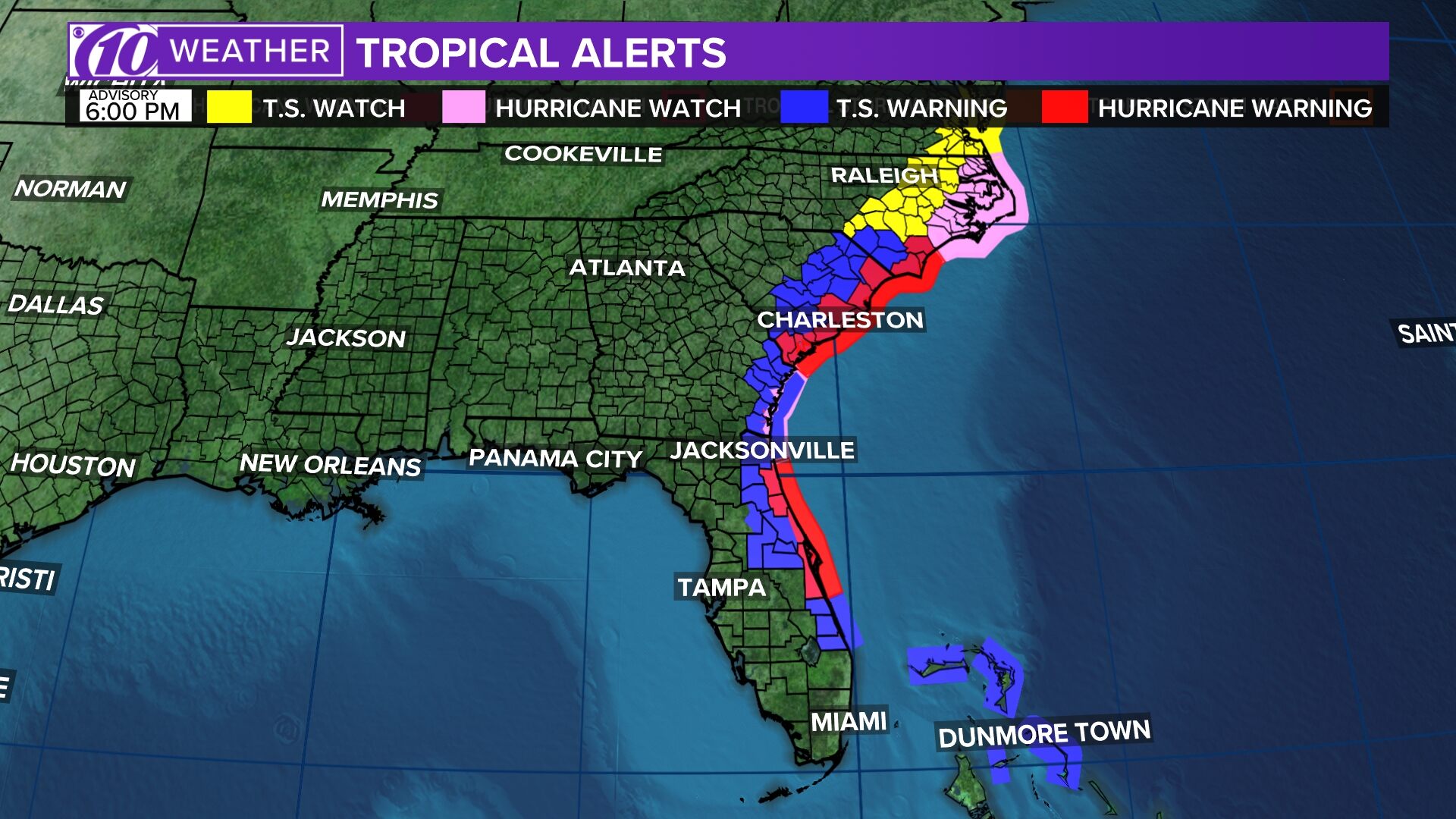
Watches and warnings
What’s a watch? What’s a warning? Here are the official alerts that can be issued for your area and what you should do.
App users — tap here if you cannot see the image below.
