- New Jersey declares emergency as nor’easter approaches, while Alaska flooding carries away homes
- Road closures reported due to flooding in Myrtle Beach
- Town of Wrightsville Beach preparing for coastal flooding this weekend
- Man charged with sparking the most destructive wildfire in Los Angeles history
- Carolina Hurricanes start 2025-26 season hosting New Jersey Devils
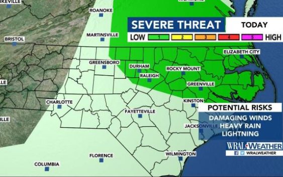
Severe weather possible late Monday; hot and humid week ahead
Raleigh, N.C. — Storms are likely Monday evening across central North Carolina, and the entire week will be hot and sticky.
“We’ll see partly to mostly cloudy skies with scattered showers and storms possible,” WRAL meteorologist Mike Maze said.
Areas from the Triangle northeast are under a level 1 threat for severe weather on Monday, meaning damaging winds, lightning and heavy rain are possible.
There is a 30 percent chance for rain Monday afternoon and evening in Raleigh. By 8 p.m., rain chances decrease to 20 percent.
The same conditions are reflected throughout the forecast.
“We will be closely monitoring a front that will waver near North Carolina throughout the week,” Maze said. “A few weak disturbances will ride along the front this week and bring the chance for scattered, late day showers and storms, but we aren’t expecting washout conditions any day.”
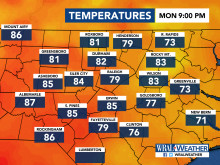
Monday featured seasonal warmth and humidity, with temperatures in the mid 80s to low 90s. The humidty will rise throughout the evening along with the chance for showers.