- U.S.-based aid groups rush to get supplies into storm-battered Jamaica after Hurricane Melissa
- Travelers stuck in Jamaica due to Hurricane Mellissa forced to pay for unwanted extended stay
- Raleigh police officer awaits word from family in Jamaica after Hurricane Melissa devastation
- North Carolina’s leaders give insight on the effects of Hurricane Melissa
- ‘We want some answers;’ Whiteville residents demand city response to prevent flooding
Path released for storm expected to become Tropical Storm Humberto
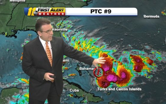
The tropical system developing near the Bahamas is expected to become a named tropical storm Saturday.
The National Hurricane Center officially designated the storm Potential Tropical Cyclone 9. PTC 9 had sustained winds of 30 miles per hour as of Friday morning–to become a tropical storm it must have sustained winds at or above 39 mph.
An early estimated track of PTC 9 has it heading through the Bahamas, into Florida and up the East Coast.
SEE ALSO: Video shows widespread destruction in Bahamas after Hurricane Dorian
At this time, the National Hurricane Center does not believe the system will develop into a hurricane. Still, it could bring significant wind and rainfall to the Bahamas and parts of Florida.
The Bahamas are under a Tropical Storm Warning and part of the Atlantic Coast of Florida is under a Tropical Storm Watch.
Keep in mind we’re still in the peak of hurricane season. We’ll keep you updated on any changes.
Copyright © 2019 WTVD-TV. All Rights Reserved.