- EF-1 tornadoes ripped through Cypress, Waller County areas with winds at more than 100 mph, NWS reports
- Houston-area storm damage updates: Clean up continues after NWS says two EF-1 tornadoes and powerful derecho ripped through SE Texas
- Low risk of damaging winds, hail from Saturday storms
- EF 1 tornadoes ripped through Cypress, Waller County areas at more than 100 mph, NWS reports
- Caddo Mounds State Historic Site to celebrate new visitor center, traditional grass house after 2019 tornado
Imelda triggers tornado in east Harris County, more heavy rain in Houston
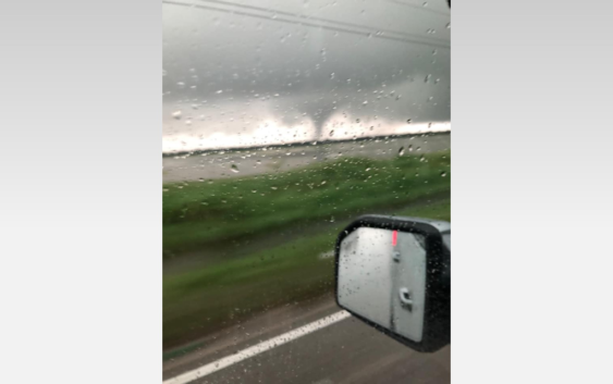
HOUSTON — Tropical Depression Imelda is still spinning up trouble in the Greater Houston Area.
At least one tornado touched down in east Harris County around 5 p.m. Wednesday. Brian Lockwood was on FM 1942 when he snapped a photo of it moving west toward Mont Belvieu.
The system also brought another round of heavy rain just in time for rush hour headaches.
A Flash Flood Watch is in effect for southeast Texas and extreme southwest Louisiana until Thursday morning at 7 a.m.
RELATED: Imelda: 24-hour rainfall totals range from deluge to a drop or two
HIGH WATER LIST: High water locations on major roads across Houston
MAP: Steer clear of these flood-prone spots in Houston
As of 10 a.m. Wednesday, Imelda was located about 65 miles north of Houston. It had max sustained winds of 30 mph and was moving north at 5 mph.
Here’s the latest weather timeline from the KHOU 11 Weather Team:
Wednesday Afternoon:
The flood threat remains high because the ground is very saturated.
Wednesday Night:
Heavy rain will continue to push out of our area to the east.
Thursday Morning:
The circulation should be well out of the Houston area by this time. However it will still drag rain showers, some heavy, in behind the storm. Flood threat moderate as the grounds remain saturated.
RELATED: Map: See which Houston streets get the most flooding calls
DOWNLOAD OUR NEW APP: To stay weather aware and get the latest alerts, tap here
Thursday night & Friday:
Rain chances are expected to diminish. Flood threat low to moderate.
HOUSTON RADAR: Imelda weakens to a depression
RELATED: 5 ways to prepare for potential flooding
RELATED: Gov. Abbott places several state resources on standby in front of possible flooding
WEATHER RADAR: Track rain & storms across Texas
Five ways to prepare for flooding
There are five things you can do right now to make sure you’re ready.
1. Register for AlertHouston
Alert Houston is how the City of Houston sends out critical emergency information. It will alert you via email, text, phone call, or push alert. You can get geo-targeted warnings at your location. You can also register up to five addresses.
2. Register for Harris County’s Flood Warning System
FWS monitors rainfall at more than 250 locations along bayous, creeks, and rivers. It will alert users in real time as water levels rise through email and/or text message.
3. Look at Houston’s Flood Prone Map
The City of Houston Office of Emergency Management partnered with Houston Public Works and TxDOT to identify over 100 flood prone roadways. Drivers should check the map before rain events.
4. Download the Transtar App
The Transtar app allows you to monitor road conditions in real time. It also shows regional alerts and active incidents on an interactive map. (Android users, tap here.)
5. Pay attention to meteorologists
Visit our KHOU Weather page.