- Rock Hill storm damage costs are 'somewhere around $5 million.' That number doesn't include damage to personal property
- Rock Hill storm damage costs are 'somewhere around $5 million.' That number doesn't include damage to personal property
- ‘Somewhere around $5 million’ | Rock Hill officials see major storm damage costs
- The deadliest tornadoes to ever hit Austin
- Whiteville resident recalls events from Tuesday nights tornado
Warnings expire; tornado watch in place for Dallas-Fort Worth until 2 a.m.
This is a breaking story that will be updated throughout the night.
Severe storms developed in the Dallas-Fort Wort metro area on Sunday night. The system brought hail, lightning and at least one confirmed tornado, first spotted north of Love Field in Dallas around 9 p.m.
RELATED: DFW weather: Dallas Fire-Rescue responding to structure collapse at Harry Hines and Walnut Hill
Tornado warnings for parts of Ellis, Dallas and Collin counties had expired Sunday as the storms continued to move east. Severe thunderstorm warnings in the area had also expire.
However, a tornado watch remains in place until 2 a.m. A second system of storms is expected to move through the region later.
Check this link for all of the latest storm warnings and watches.
Download our free WFAA app to stay up-to-date on all news stories in the Dallas-Fort Worth area, including weather.
See below for a detailed timeline of what to expect overnight.
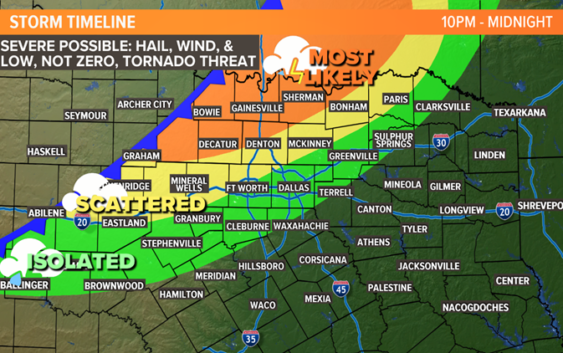
TONIGHT (10 P.M. – MIDNIGHT)
Scattered storms from earlier in the night will start to form a line during this time. The areas that will see the best chance for storms during this time will be western and northern North Texas.
The threat of severe storms will continue. Large hail and damaging winds will continue to be the main threats, but we can’t rule out an isolated tornado.

WFAA
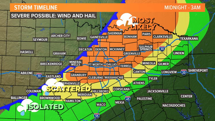
SUNDAY NIGHT TO MONDAY MORNING (MIDNIGHT TO 3 A.M.)
A line of thunderstorms will start to sweep across North Texas.
Severe storms are possible with this line of storms as well. Damaging winds and large hail will be the main threats. We can’t rule out a spin-up tornado within the line. But since the storms will be in a line, the tornado threat is much lower.
WFAA
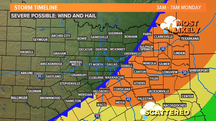
EARLY MONDAY MORNING (3 A.M TO 7 A.M.)
The round of storms will continue to move from west to east across North Texas. But storms will also end from west to east.
The closer to sunrise Monday, the farther east the storms will be. By daybreak Monday, most storms will be in East Texas.
WFAA
REST OF THIS WEEK
Monday will be cooler and breezy behind the cold front. Most of next week will be very fall-like.
Another front is due to arrive Thursday into Friday, bringing back chances for showers and storms. That front could have even cooler air behind it with much cooler temperatures by Friday into next weekend.