- Southport hosts annual Hurricane Expo ahead of the 2024 season
- How to protect your car before a hailstorm
- ‘We lost everything’: East Texas residents confront their future after flooding
- Here's how to get your flooding debris picked up by the City of Houston
- Mosquito activity on the rise due to rainfall, flooding across Texas
Nor'easter's damaging waves, life-threatening flooding expected along Outer Banks
A powerful coastal storm off the Atlantic coast of the Carolinas this weekend will batter the shoreline with dangerous weather and surf, especially along North Carolina’s Outer Banks.
Storm warnings were posted ahead of the storm to warn residents of the impending severe weather.
“Confidence is high that this event will occur, and we are expecting significant impacts,” the National Weather Service said in a Saturday morning brief. “Storm force winds and dangerous seas over the coastal waters, sounds and rivers [are expected].”
The National Weather Service in Wilmington, North Carolina, which has forecasting jurisdiction for the Outer Banks, is calling for the “potential for life threatening inundation 2 to 4 feet above ground level for [the] ocean side.” Minor flooding up to 2 feet above normal is expected along the inner Pamlico Sound and rivers.
“High surf, beach erosion and ocean over wash expected for the beaches north of Cape Lookout,” the weather service warned. “The most significant ocean side impacts are expected north of Cape Hatteras. Portions of Highway 12 likely inundated and impassable at times.”
While not tropical in nature, the Nor’easter could pack winds near hurricane-strength.
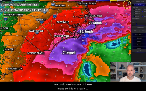
“Winds almost sustained at 50 mph on Frying Pan Tower,” WCNC Storm Team Chief Meteorologist Brad Panovich observed Saturday as the storm strengthen.
If this was a tropical system, sustained winds between between 39 and 73 mph would be considered a tropical storm. Winds are the center of a tropical system sustained near the eye greater than 74 mph would be considered a hurricane.
Along the Outer Banks this weekend, the Nor’easter is expected to bring winds upwards of 70 mph, according to the National Weather Service.
Winds were gusting as high as 20-30 mph across central and western portions of the Carolinas a result of the offshore storm.
A welcomed sight to surfers ahead of the storm, the Nor’easter could bring dangerous surf during its peak.
Wave heights near the shore could be as high was 12 feet, with waves as tall as 20 feet further offshore Sunday.
Waves, onshore winds, and 4-6″ of additional rainfall, are expected to cause flooding and erosion along the coast.
Panovich is warning of flooding potential all along the Pamlico River and and Neuse River, as strong winds will push the water onshore.
“We could actually see impacts over a larger area than we saw from Hurricane Dorian,” Panovich said.
Before arriving in the North Carolina Outer Banks overnight Saturday into Sunday, the storm strengthen off the coast of South Carolina and Georgia.
In brought moderate flooding to Charleston, South Carolina, where numerous streets were flooded in downtown Charleston along the Battery.
Outer Banks residents have been told to prepare for power outages and flooded roadways, which could cut them off from the mainland or neighboring communities.
In neighboring Virginia, residents of Norfolk have been warned to move their cars to higher grounds ahead of flooding.
RELATED: Norfolk allowing residents to move vehicles to city garages due to nor’easter causing flooding
Over the weekend, the storm will continue to travel north offshore of the Atlantic coastline, where it will eventually move into the Northeast.
More weather news:
RELATED: Venice faces dramatic flooding for 2nd time this week
RELATED: Thousands of ‘ice eggs’ cover Finland beach in rare weather event
RELATED: Arctic air sends temps tumbling; mountains see snow
RELATED: Passenger video shows plane sliding off runway at Chicago O’Hare