- Tropical Storm Melissa lumbers through the Caribbean as islands take cover from rain
- Tropical Storm Melissa brings flood risk to Haiti, Dominican Republic and Jamaica
- Army Corps evaluates Wrightsville Beach storm damage; could accelerate re-nourishment plans
- Austin and Travis County issue disaster declaration as wildfire risk rises
- Raleigh rethinks how to grow as flooding, heat and traffic worsen
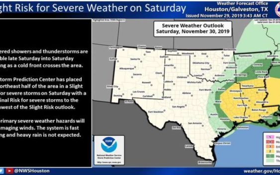
Cold front moves into Houston bringing showers and possible tornadoes
-
A cold front on Saturday afternoon may bring a chance of severe weather.
A cold front on Saturday afternoon may bring a chance of severe weather.
Photo: National Weather Service
A cold front on Saturday afternoon may bring a chance of severe weather.
A cold front on Saturday afternoon may bring a chance of severe weather.
Photo: National Weather Service
Get ready for a wet weekend.
The National Weather Service is predicting scattered showers and thunderstorms across parts of our region starting Saturday that may bring “damaging winds and isolated tornadoes.”
The severe weather doesn’t begin until late Saturday when a fast-moving cold front will cross into the area, bringing with it a slight risk of severe storms, according to meteorologists.
READ ALSO: Suspect shot during west Houston gas station robbery
On Friday, Houstonians can expect a “warm front” to move into the area ahead of Saturday’s severe weather. The warm front will leave patchy dense fog and light rain over much of Houston and will bring high temperatures into the upper 70s.
Temperatures on Saturday night will drop into the 50s.
Michelle Iracheta is a digital reporter in Houston. Read her on our breaking news site, Chron.com, and on our subscriber site, houstonchronicle.com. | michelle.iracheta@chron.com