- Hurricane survival kit: How to keep your family safe when a hurricane hits
- Houston-area storm damage: Update on status of schools, power outages and resources for storm victims
- EF-1 tornadoes ripped through Cypress, Waller County areas with winds at more than 100 mph, NWS reports
- Houston-area storm damage updates: Clean up continues after NWS says two EF-1 tornadoes and powerful derecho ripped through SE Texas
- Low risk of damaging winds, hail from Saturday storms
As many as 10 states face major threat of severe weather as week progresses
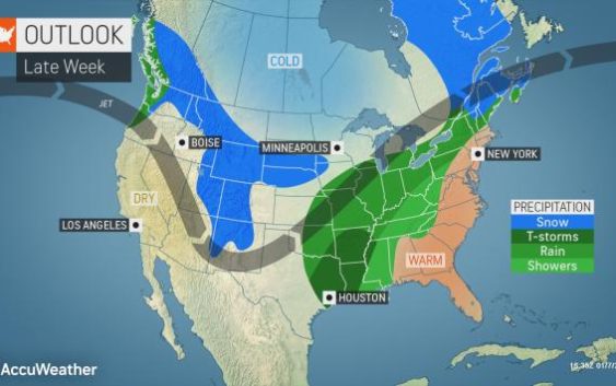
The weather will take a volatile turn heading into the first weekend of January, with millions of Americans under the threat for severe thunderstorms, including the potential for tornadoes.
The threat zone will include major metro areas such as Dallas, Houston, New Orleans and Nashville, likely leading to travel headaches. AccuWeather meteorologists warn that some of the most hazardous weather could occur after dark.
“Residents and visitors will need to be extra vigilant, as many people may not think about severe weather in January,” AccuWeather Meteorologist Ryan Adamson said.
A strong cold front poised to sweep through the Southern states Friday into Saturday will be the trigger for the violent weather.
Warm, moist air flowing in from the Gulf of Mexico ahead of this system, combined with twisting winds in the lower part of the atmosphere, will contribute to a heightened risk of severe thunderstorms and tornadoes.
“On Friday afternoon, thunderstorms are forecast to erupt in southeastern Oklahoma, as well as central and eastern Texas,” Adamson said.
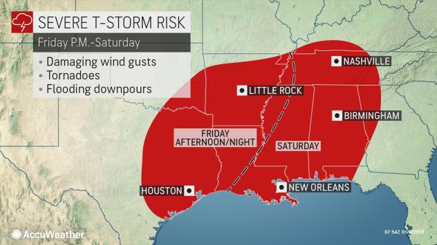
The storms may keep every bit of their punch as they race eastward into the lower Mississippi Valley during Friday night in the form of a squall line.
Straight-line wind gusts to an AccuWeather Local StormMax™ of 70 mph can occur Friday afternoon and night, leading to broken tree limbs, some structural damage and power outages. Forecasters say flooding downpours and tornadoes are also a big concern.
“Some strong tornadoes are not out of the question,” Adamson said. “The tornado threat will be highest in any individual thunderstorm cells that develop ahead of the main line, but tornadoes are possible anywhere in the threat zone.”
Residents from Houston to Little Rock, Arkansas, should consider charging their cellphones and leaving them on with severe weather alerts enabled and the volume turned up before heading to bed.
Motorists traveling along stretches of interstates 10, 20, 30, 45 and 49 will be at risk of facing torrential downpours and a heightened risk of hydroplaning.
“The line of thunderstorms will move eastward into Tennessee, Mississippi, Alabama and the Florida Panhandle on Saturday,” Adamson said.
Cities such as New Orleans, Nashville, Birmingham and Montgomery, Alabama, and perhaps as far east as Atlanta could be hit by storms capable of producing torrential downpours, damaging winds and isolated tornadoes.
People scheduled to arrive in the Big Easy on Saturday ahead of the College Football Playoff National Championship game on Monday, Jan. 13, should anticipate delays.
As the system moves along, locally damaging winds in lieu of severe weather may cause broken tree limbs and power outages across the region, especially in areas where the ground is saturated.
This same system will encase a 1,700-mile swath of the nation in ice and snow, while contributing to near-record warmth in portions of the Northeast and unleashing flooding rainfall across the Ohio Valley.