- $40 million to go to underserved SC counties for Hurricane Helene recovery. Here's what you need to know.
- Family honors Air Force veteran Derwin Anderson Jr. after he died in June flash floods
- City of Wilmington addresses flooding on New Centre Drive
- Harnett County fire: Two homes damaged
- Medical examiner identifies 13th victim from massive flash flood in San Antonio
Tornado warning in effect for Harris, Montgomery and Waller counties until 11:15 p.m.
HOUSTON — A tornado warning is in effect for Harris, Montgomery and Waller Counties until 11:15pm. A tornado watch has been issued for southeast Texas until 4 a.m. Saturday.
Severe weather, including damaging winds and hail, is possible from Texas into Arkansas, Louisiana, Oklahoma and Tennessee late Friday into the very early-morning hours Saturday.
Our neighbors in North and East Texas will want to keep a very close eye on this system.
RELATED: Tornadoes, large hail possible in DFW area
RELATED: Several flights cancelled in Dallas-Fort Worth ahead of tonight’s storms
It’s too soon to say which parts of the Houston area will get the worst of the weather, if any, but given that this will likely be a nighttime event we’ll all want to make sure we stay alert and keep an eye on the radar tonight.
After the storms roll through, we are in for nicer conditions the rest of the weekend but with colder temperatures.
GET ALERTS ON YOUR PHONE: Download our new app
TRACK THE STORMS: View weather radars
ARE YOU READY? How to set up weather alerts on your phone
As of 6:45 pm Friday evening the greatest threat for severe storms remains to the north of the Houston area.
However, we expect to see a line of strong thunderstorms move across the Houston area between 10 pm and 2 am tonight. This line could produce damaging wind gusts and maybe an isolated tornado in isolated spots.
WHAT TIME WILL THE STORMS SWEEP THROUGH HOUSTON?
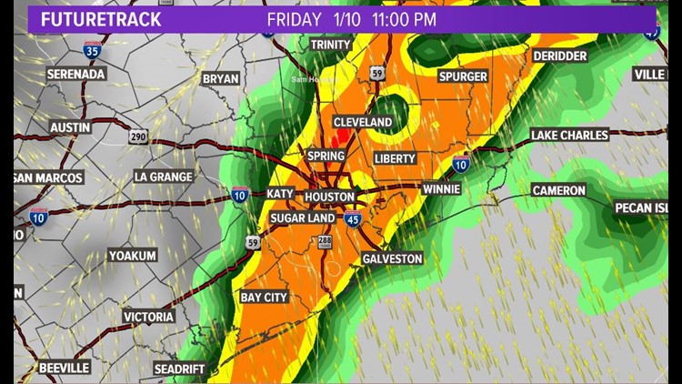
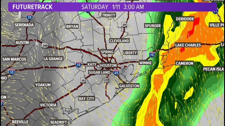
You can expect the worst of the weather to moving into Houston’s western counties at about 10 p.m. with the storms rumbling in Houston proper around midnight. Liberty and Winnie by 1 a.m. then off to Beaumont and Lake Charles between 2 and 3 am.
Heading north? View the detailed weather forecast for the Dallas area and East Texas here.
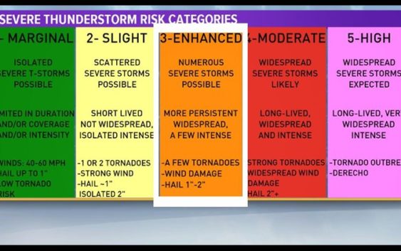
WHAT DOES AN ‘ENHANCED RISK’ FOR SEVERE WEATHER MEAN?
We are in a category 3 out of 5 for severe weather. Which is an Enhanced risk, from the Storm Prediction Center, for severe weather for Friday afternoon, into the overnight hours going into Saturday.

KHOU
In the Houston area, we have the potential for strong to severe storms with the potential for several damaging elements. This includes the possibility of a few tornadoes, wind damage and 1- to 2-inch hail.
Portions of East Texas and North Texas, east of Dallas, have a higher risk of severe weather, as of the latest forecast. This means they have a better chance of widespread storms with strong tornadoes possible.
WHAT DOES THE REST OF THE WEEKEND LOOK LIKE?
The rain clears out before sunrise Saturday, leaving us with a nice (but cold) weekend. Our temps will go from a high of 80 degrees Friday to not even getting out of the 50s on Saturday. Sunday morning we’ll be in the 30s before sunrise before ‘warming up’ to a high of 60.
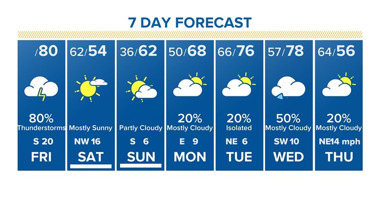
7-day forecast for Houston as of 6 a.m. Jan 10 2020
KHOU 11
Check back for more updates, and you can always follow us on Twitter and Facebook, as well as download the KHOU 11 Weather App in your app store.
Send us a news tip | Download our app | #HTownRush Newsletter
WHAT’S CAUSING THE SEVERE WEATHER OUTBREAK?
The jet stream, that river of air aloft that steams storms around the planet, has it digging down towards western Texas, and rising up in eastern Texas. Which has us almost in the Right Rear Quadrant, which has a higher chance or producing storms with the potential for going severe.
As we look at a cross section of the atmosphere, we have winds at the surface coming from the south, and winds aloft coming from the southwest; which means they are the winds are turning with height, thereby increasing wind shear. Which, if you have the right amount of turning, you can get storms to rotate, increasing the chances for possible tornadoes.
KHOU
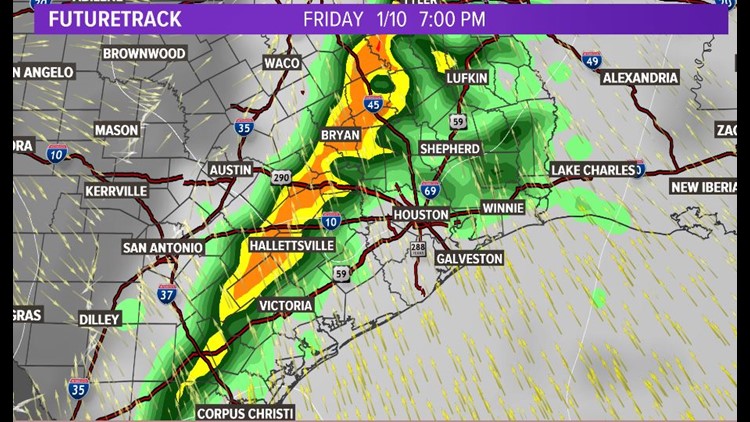
Now here is the cold front approaching us. At 7 PM, we have light rain across some areas, with the heaviest pushing through Bryan and Hallettsville.
KHOU
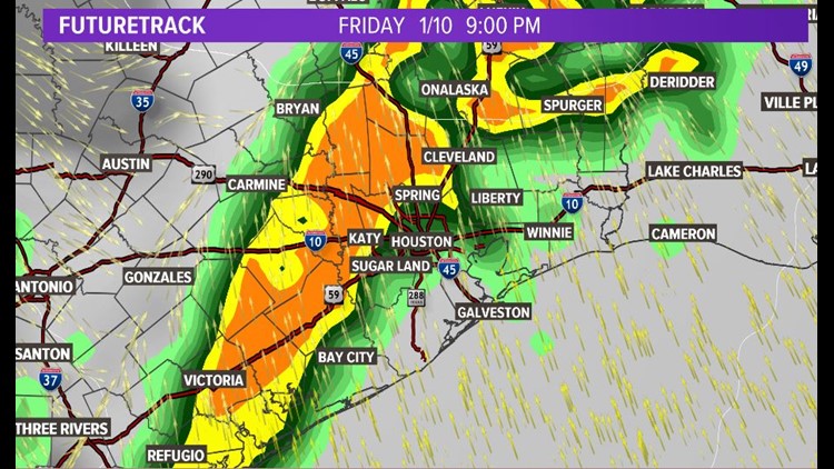
By 9 PM, the storms are pushing towards the Beltway. Places like Katy, Spring and even Sugar Land are starting to see heavy rain & get gusty winds.
KHOU
Between 9 PM and 11 PM, the worst weather is right over the metro. Heavy rain could lead to localized street ponding with strong winds, and we could possibly see hail & some embedded tornadoes in that line.
KHOU
The storms will wrap up from west to east, with the last of the rain falling over our eastern towns well after midnight.
With this being our first experience of severe weather for 2020, we might be a little rusty in with what to do, and where to go when severe storms come our way. Make sure to have multiple ways of getting the vital information, such as social media, your tv, and of course, the KHOU11 app. And if you are out and about, since it is a Friday night, make sure to have multiple ways of getting to safety.