- Two people, including a child, dead after Oklahoma tornadoes; governor declares state of emergency
- Build your hurricane season preparedness kits this tax-free weekend
- Residents begin going through the rubble after tornadoes hammer parts of Nebraska and Iowa
- Midwest tornadoes flatten homes in Nebraska suburbs and leave trails of damage in Iowa
- WATCH: Massive tornado caught on camera in Iowa
Severe Storms & Flooding Possible Today
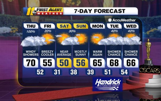
As a cold front pushed into southern Virginia late yesterday, it helped to bring a deep pooling of moisture over northwest and northern North Carolina, including over the Triangle. The deep moisture brought a few showers to the region with an almost steady rain occurring near and to the north of the North Carolina/Virginia border. That front is now lifting to the north as a warm front early today.
A surface storm moving toward Chattanooga, Tennessee, will eventually wind up in eastern Pennsylvania by early tomorrow morning. The southward extension of the current front moving south through southern Virginia will move eastward as the surface storm tracks to the north and east.
Ahead of this front, unseasonably warm, moist and unstable air will bring lots of clouds and spotty showers across central North Carolina through early this afternoon. Then, as the front moves closer, more numerous showers and thunderstorms will work their way eastward across central North Carolina this afternoon and this evening.
The front will reach the Triangle this evening. Some of the thunderstorms along the leading edge of the front will bring gusty, perhaps damaging winds and brief heavy rainfall. The front should moves east and south out of most of central North Carolina by midnight.
In the wake of that cold front, dry, more stable air will bring a break up in the clouds later tonight. Tomorrow will turn out partly sunny and cooler. High pressure building eastward will help bring more cooler air for tomorrow night into Saturday.
A weak, upper-level disturbance moving over Virginia and North Carolina late Saturday and Saturday night will force a weak cold front through the region Saturday night and early Sunday morning. This will bring thicker clouds Saturday afternoon and may cause a spotty shower late Saturday, Saturday night and early Sunday morning. This whole system moves east by Sunday morning and the rest of Sunday will turn out partly sunny with near-average afternoon high temperatures for early February.
Have a great Thursday and stay weather aware for the possibility of severe storms today!
Bigweather
Check the radar anytime with the free AccuWeather app for iPhone and Android today!
Copyright © 2020 WTVD-TV. All Rights Reserved.