- Hurricane survival kit: How to keep your family safe when a hurricane hits
- Houston-area storm damage: Update on status of schools, power outages and resources for storm victims
- EF-1 tornadoes ripped through Cypress, Waller County areas with winds at more than 100 mph, NWS reports
- Houston-area storm damage updates: Clean up continues after NWS says two EF-1 tornadoes and powerful derecho ripped through SE Texas
- Low risk of damaging winds, hail from Saturday storms
Tornado Warnings, Watches issued for Charlotte area as storms move across Carolinas
CHARLOTTE, N.C. — Multiple Tornado Warnings have been issued in the Charlotte area as a line of strong thunderstorms move across the Carolinas.
The first Tornado Warnings were issued in Cleveland, Gaston and Lincoln Counties around 9:50 a.m. The second warning was issued for Catawba and Lincoln counties until 11 a.m. A funnel cloud was reported near Shelby in Cleveland County, prompting the tornado warnings.
“Anyone that’s along this line, just note that this is a line of strong winds,” said First Warn meteorologist Chris Mulcahy.
A Tornado Watch is in effect until 5 p.m. for most of the Charlotte area. These counties include Catawba, Cabarrus, Cleveland, Iredell, Lincoln, Mecklenburg and Union.
Chief meteorologist Brad Panovich says anyone in the storm’s path should be hypersensitive to the conditions.
“Anywhere along this line, I’m going to tell you to treat this line like it’s under one giant severe thunderstorm or tornado warning,” Panovich said. “Every single county along that line is under a Flash Flood Warning. Even if you’re not in the current warning areas, you’re going to be in some type of threat later.”
Some areas in the foothills reported wind gusts up to 58 mph, with some roads underwater in Burke and Catawba Counties. The mountains have seen a tremendous amount of rain with yet another line of storms expected Thursday afternoon. Flooding and downed trees will be the biggest concerns for most of the Charlotte area as the storms move through the region.
“Even if it the rain lets up for a second, don’t let your guard down,” Panovich said. “This is not the end of the event, it is really going to be picking up as we go into the afternoon.”
Panovich explained that there is a threat for isolated tornadoes and damaging winds with these storms but the biggest threat will be flooding. There have been multiple reports of downed trees across the Charlotte area.
Some areas in the mountains have already seen up to 4 inches of rain from the first wave of storms. Creeks were seen overflowing their banks in Burke County. Mulcahy reported rain rates over more than 2 inches per hour with the storms.
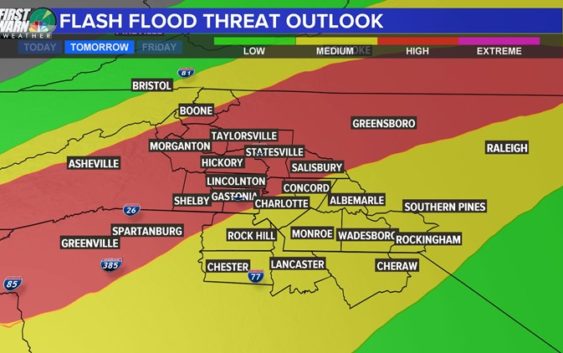
The entire Charlotte area is under a Flash Flood Watch until early Friday. Panovich said this system has created flash flooding everywhere it’s been so far and expects some Flood Warnings Thursday. Several school districts announced they will be dismissing early due to the forecast.
Panovich says the second line of storms shows the potential for some rotation, which is a general indicator of severe weather.
“This doesn’t mean there’s a tornado, it just means there’s rotation with the line, which does correlate to severe storms,” Panovich said.
The National Weather Service issued a flash flood watch for the entire Charlotte area effective 6 a.m. Thursday. The mountain counties were already under a flash flood watch as storms will roll into the region late Wednesday and overnight.
“I don’t want to discount that threat, but flooding is by far our biggest issue. You’re 10 times more likely to see flooding than any other severe weather,” Panovich said.
“They’re small, but for this time of year, it’s elevated, I’m not going to lie,” Panovich said. “For February, that’s a pretty significant tornado threat, especially areas south of Charlotte, like Columbia, South Carolina.”
Panovich said more than widespread tornadoes, it looks like a possibility for a couple of spin-ups.

WCNC
“Just wave after wave of heavy rain,” Panovich said. “There will be a lull at some point. It will be cloudy, but the clouds will be thin and we’ll be getting warm, humid air from the south. A backdoor cold front will be pushing in, and these winds are probably going to be rotating in the higher elevations, so the storms could produce higher winds.”
The second wave of storms Thursday afternoon will bring the biggest risk of severe weather. Panovich says the worst will likely be from around 3 p.m. through about 7.
There will be heavy rain and thunderstorms across the Carolinas until the early hours Friday morning.

“There will be a ton of rain. That’s a given,” Panovich said. “The only question is how widespread the severe weather is. Really strong winds are mixing down to the surface, and are we going to have rotating storms? We don’t have a real good handle on where the rotation might occur just yet.”
Once the storms clear, Panovich expects a pretty big snow event for the mountains. By Friday, skiers will have plenty of options to hit the slopes in the high country.
The bottom line?
“There’s a 100% chance we’re going to see some flooding somewhere,” Panovich said. “There will be heavy rain for everybody, the question is how widespread the damaging winds and severe weather are.”
SEVERE WEATHER TIPS FROM BRAD PANOVICH