- $40 million to go to underserved SC counties for Hurricane Helene recovery. Here's what you need to know.
- Family honors Air Force veteran Derwin Anderson Jr. after he died in June flash floods
- City of Wilmington addresses flooding on New Centre Drive
- Harnett County fire: Two homes damaged
- Medical examiner identifies 13th victim from massive flash flood in San Antonio
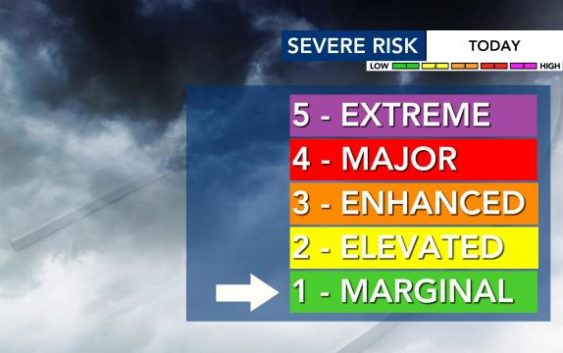
Level 1 severe weather threat means rain, winds for Triangle throughout the evening
Raleigh, N.C. — A storm system that spawned deadly tornadoes in Tennessee will make its way across North Carolina this afternoon and evening, bringing the threat for damaging winds.
The Storm Prediction Center posted a Level 1 alert for central North Carolina. Download the WRAL Weather App to get alerts on your mobile device.
Rain showers moved into the Triangle around lunchtime and more severe storms are possible as early as mid-afternoon and during the evening commute, according to WRAL meteorologist Aimee Wilmoth.
“A few of those could produce wind damage or an isolated tornado,” Wilmoth said.
The storms and tornadoes resulted in 19 deaths and significant structure damage in Tennessee, but their severity will lessen by the time they reach North Carolina.
“That same system that brought the devastating tornadoes to Nashville is moving our way; however, the bulk of the energy that created all those tornadoes will go to our north,” said WRAL meteorologist Elizabeth Gardner.
Polls are open through 7:30 p.m., and anyone in line at that time will be allowed to vote. If people choose to vote after lunchtime, they will probably get wet. “It will be an on-and-off rain, not a steady rain,” Gardner said.
Track the rain with the DualDoppler5000.
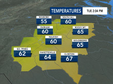
Voters should at least be warm, as temperatures should climb into upper 60s. It will be windy, with gusts at 15 to 20 mph at times.
The system will move away by Wednesday, which will be warm and dry with partly cloudy skies and temperatures in the upper 60s.
The rain returns Thursday as temperatures drop into the 50s. The weekend will be dry but cooler, with highs in the upper 50s.
