- $40 million to go to underserved SC counties for Hurricane Helene recovery. Here's what you need to know.
- Family honors Air Force veteran Derwin Anderson Jr. after he died in June flash floods
- City of Wilmington addresses flooding on New Centre Drive
- Harnett County fire: Two homes damaged
- Medical examiner identifies 13th victim from massive flash flood in San Antonio
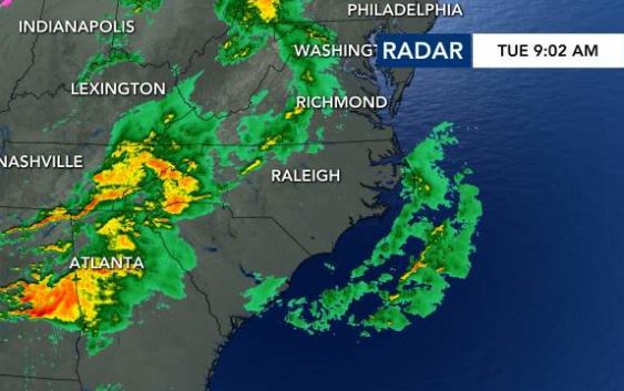
Triangle under Level 1 threat for severe weather as system from Tennessee moves east
Raleigh, N.C. — Spring-like weather has returned to the Triangle this week, bringing rain and warmer temperatures along with it.
Tuesday morning was cloudy, with temps a pleasant 57 degrees. However, rain and showers from the system impacting Tennessee are forecast to head into North Carolina by the afternoon.
“That same system that brought the devastating tornadoes to Nashville is moving our way; however, the bulk of the energy that created all those tornadoes will go to our north. Still, the storm prediction center just put us under a level one risk for severe weather,” said WRAL meteorologist Elizabeth Gardner.

Will the rain, wind and storms impact voters waiting in lines at the polls? Gardner offered an hour-by-hour breakdown to help voters avoid waiting in the rain.
“If you’d like to make it to the polls without getting wet, I recommend going as early as you can,” she said.
“It will be an on-and-off rain, not a steady rain,” said Gardner.

There’s a better chance for showers and thunderstorms closer to lunchtime and potential for windy conditions.
Voters should at least be warm, as temperatures should climb into upper 60s.

Wednesday will be warm and dry, with partly cloudy skies and temperatures in the upper 60s.
The rain returns Thursday, as temperatures drop into the 50’s.
The weekend will be dry but cooler, with highs in the upper 50s.
