- Asheville's resilient lodges welcome back travelers after Hurricane Helene
- Austin leaders consider expanding wildfire protection plan
- Large hail, strong winds and tornado threat possible into Thursday evening
- Large hail, tornado threat possible Thursday evening
- 'Welcome to Aggieland Atlantis': Texas college town floods during finals week
Level 1 threat for severe weather means gusty winds, storms again today
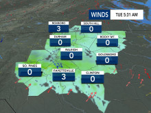
There is another level 1 threat for severe weather on Tuesday.
According to WRAL meteorologist Elizabeth Gardner, the National Weather Service has much of central North Carolina under a Level 1, or marginal, risk for severe storms.
Gardner said the biggest threat could be gusty winds as a storm system moves into the state from the northwest. The first half of the day will be clear, but the chance for scattered storms will move in late Tuesday afternoon.
The timing will mimic Monday, when storms began popping up to the west of the Triangle around 3 p.m. after temperatures reached about 80 degrees. The storms cleared the area by 8 p.m. or 9 p.m.
A similar pattern is in place for Tuesday, with the storm probability slightly higher and the start of any outbreaks coming earlier, especially north and west of the Triangle.
“Not everybody will see storms,” Gardner said.
Not everyone will see rain on Tuesday. The chance is only about 40%, Gardner said. There is an even lower chance, but still a chance, for storms on Wednesday.
The middle of the week looks sunny and warmer, with highs in the mid 80s for Wednesday and Thursday, about 15 degrees above normal. On Wednesday, the forecast high of 87 degrees could bring the Triangle close to tying or breaking a record for the day.
Highs will fall into the mid 60s for Friday and the weekend.
