- Severe weather leads to fallen trees, car crashes and flooding around the Triangle
- New video shows vehicles being swept away in historic, deadly flash floods in SA on June 12
- $40 million to go to underserved SC counties for Hurricane Helene recovery. Here's what you need to know.
- Family honors Air Force veteran Derwin Anderson Jr. after he died in June flash floods
- City of Wilmington addresses flooding on New Centre Drive
Timeline: When to expect a chance for severe weather in the Houston area

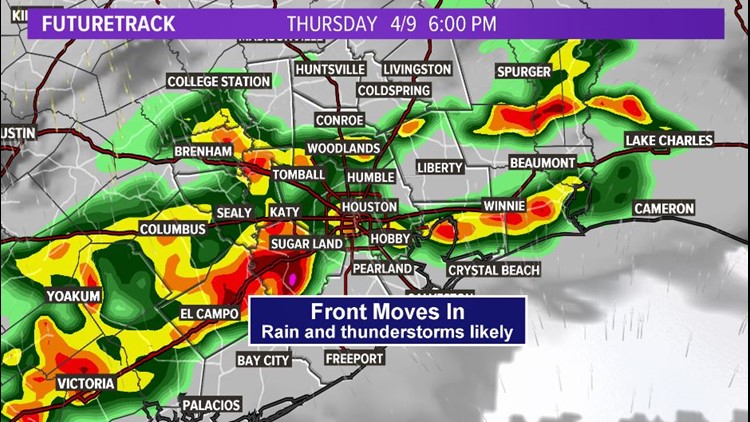
HOUSTON — A threat for severe storms returns to Southeast Texas and parts of the Houston area late Thursday, according to KHOU 11 Meteorologist Chita Craft.
The greatest chance to see severe conditions will be in our southwest counties and areas west of Houston.
TRACK THE WEATHER: Houston weather radar
WEATHER ALERTS ON YOUR PHONE: Download the new KHOU 11 app
What to expect
At minimum, it appears heavy rain, lightning and thunder will be pretty widespread with some rain rates in the heavier storms as high as 1 to 2 inches of rain per hour, reports Meteorologist Blake Mathews.

khou
“Microbursts with winds in excess of 70 mph and large hail appear to be the primary threats. Isolated tornadoes can’t be ruled out,” says Mathews. “While widespread flooding is not expected due to the fast nature of the storms, localized ponding in the usual suspect spots can be expected. While no severe weather or tornado watches are currently in effect for our region, one may be required by Thursday afternoon.”
Timeline: When to expect the storms
7 AM — Temperatures in the 70s this morning with winds out of the southwest. Dry but very humid and muggy. Cloudy.
11 AM — Temps rise into the low-80s after sunrise as cloudy, humid (but mostly dry) conditions continue for your lunch hour. A very slight rain chance will move in for the early afternoon.
2 PM — 30% chance for rain and isolated storms in the early afternoon hours, temps in the upper-80s but due to the humidity “feels like” temps will be in the mid-90s this afternoon.
4 PM — 60% rain chance with isolated storms. Now is the time to start watching the radar, especially as we head into the later afternoon hours and early evening hours between 4 p.m. and 8 p.m. Storms will fire up west of the Houston viewing area, so those of you who live west of town will be the first to witness the onset of showers and storms.
KHOU
6 PM — 80% rain chance with storms. Radar will be busy across Southeast Texas/Houston as the line of thunderstorms moves in during the late afternoon and early evening hours.
9 PM — Chance for scattered showers and storms continues, but the severe weather threat should be over. Temps drop back into the 70s due to the rain and sunset.
12 AM — Light showers continue overnight into the very early morning hours Friday.
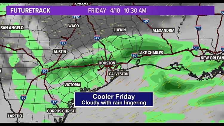
What to expect Friday and Easter weekend
For Friday, the front will be past us, but still lingering nearby, says KHOU 11 Chief Meteorologist David Paul. As high pressure moves from the Central Plains to the Mid Mississippi River Valley, we’ll have a cool, northeasterly breeze. If we couple that with the cloud cover, and scattered showers, we’ll see our air feel chilly and temps run in the 60s most of the day. We may hit 70 for a daytime high, but the chances of that are low. Think of how this past Saturday was; we had our high early in the day, clouds and showers lingers and our temps trended in the 50s. We’ll be seeing that forecast almost repeat for this coming Friday, although a touch warmer.
KHOU
By Saturday, with more rain in the forecast, we’ll still have a cool feeling in the air. Although the showers will come through nearly all day long. Temps want to get into the low 70s. Saturday could be a washout.
The rain and storms should be fading away during Easter Sunday morning, setting up for a nice afternoon. The sun will be warming up the air, and temps look to get into the low 80s. Save those Easter Egg Hunts for the afternoon hours. Although the ground will be soggy from all the rain coming our way,
Send us a news tip | Download our app | #HTownRush Newsletter