- Impact Plastics not responsible for workers killed in Helene flooding, TOSHA says
- 'A little emotional': Hurricanes equipment manager got seconds in goal, memory to last a lifetime
- WMO retires three hurricane names after devastating 2024 season
- Beryl removed from future hurricane naming lists
- Hurricane names Helene, Milton and Beryl are now retired
Tornado Watch extended for San Antonio; storms drop baseball-sized hail in parts of South Texas
SAN ANTONIO —
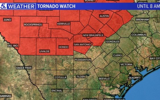
A Tornado Watch is in effect until 8 a.m. for Bexar County and much of the surrounding region.

Tornado watch until 8 a.m.
Meagan Massey
Latest update (2:40 a.m.):
The Tornado Watch for Bexar County has been extended until 8 a.m.; surrounding areas in South and Central Texas are included in the watch.
A Severe Thunderstorm Warning is in effect for Edwards, western Kerr, and Real Counties until 3:30 a.m., according to KENS 5 meteorologist Meagan Massey.
Strong to severe storms are mainly impacting the Hill Country as of 2 a.m., but storms will continue to push east and other parts of South Texas could see strong to severe storms later this morning.
While the first wave of severe weather turned north away from San Antonio just after 11 p.m. Saturday, KENS 5 meteorologists are tracking a line of storms expected to move through Bexar County between 4 a.m.and 8 a.m. Bexar County remains under a Tornado Watch until 8 a.m. Sunday.
Storms drop giant hail on parts of South Texas
Hail fell in parts of Del Rio around 8 p.m Saturday as the first wave of severe weather moved across South Texas.
KENS 5 viewers sent in the following photos of hail — some of it the size of baseballs.

Courtesy: Gabriel Flores
This size hail is considered damaging and more hail this size could be possible in some storms later this morning.

KENS viewers
RELATED: WEATHER MINDS CLASSROOM: Severe Weather 101
The storm front isn’t expected to reach San Antonio until well after midnight, but it will bring with it the possibility of more hail, damaging winds gusts and tornadoes.
Be Storm Ready | What to do before, during and after a storm
What is a Tornado Watch?
A Tornado Watch means that conditions are favorable for tornado development. People located in and around the watch area should keep an eye toward the sky and listen to their NOAA weather radio or tune to KENS 5 Eyewitness News for further weather information.
What is a Tornado Warning?
A Tornado Warning means that a tornado has been detected by the National Weather Service Doppler radar or a reliable report of a tornado has been reported from the field or indicated on radar. A tornado warning is usually issued for portions of one or two counties for an hour or less. The storm could also produce large hail and destructive straight-line winds. If the tornado warning includes your neighborhood or workplace, you should seek safe shelter immediately.
Tornado safety
In the case of a tornado warning, here are some tips for staying safe depending on where you are when the storm hits.
House or stand-alone building:
- Get to the lowest level possible
- Go to an area with as many walls between you as possible
- Get in a bathtub or interior closet
Mobile home:
- Get out of the mobile home and get in a sturdy building if possible
- Get out of the mobile home and hunker in a ditch
- If no ditch or building is nearby, plan ahead and get to a sturdy building ahead of time.
Apartment:
- Get to the lowest level (go to a neighbor’s apartment on the first floor)
- Regardless of what floor you’re on, get in a bathtub or interior closet
- If you are on a higher level and can’t get to a lower apartment, hunker down in the breezeway of the apartment building
Car:
- If possible, pull over, park, get inside a building and out of the storm
- If you have to stay in your car, try to find a ditch to park in and use your emergency brake
- DO NOT park under a bridge or overpass
Miscellaneous tips for keeping safe in a tornado:
- Cover yourself with a mattress, sleeping bags, or pillows
- Wear a helmet to protect your head
- Hunker down as much as possible
Don’t forget you can download the KENS 5 app for the latest news and weather information each day while you are on the go.