- Camp La Junta parents from Houston area head to Hunt to pick up son after deadly flooding
- Camp Director dead following devastating floods in Texas
- At least 13 dead in Texas floods and more than 20 children missing from a girls summer camp
- Several families, children missing after devastating flooding hits Texas Hill Country
- Have you been affected by the Hill Country flooding? Tell us your story.
Enhanced risk of severe weather today for central NC with damaging winds, tornadoes, flooding possible
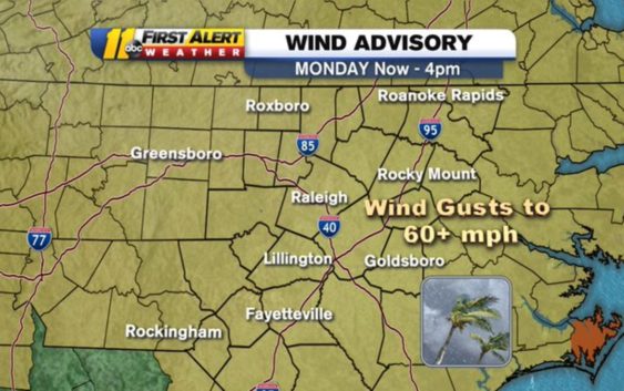
RALEIGH, N.C. (WTVD) — The National Weather Service in Raleigh has issued a wind advisory now in effect from 4 a.m.to 4 p.m. Monday and the Storm Prediction Center has our region in an enhanced risk (level 3/5) for severe weather.
A Wind Advisory is now in effect until 4pm this afternoon. Sustained winds 20-30 mph, Gusts to 60+mph. Strongest gusts between 6am – Noon, #NCwx pic.twitter.com/ULJaJ5VLBv
— 𝘿𝙤𝙣 𝙎𝙘𝙝𝙬𝙚𝙣𝙣𝙚𝙠𝙚𝙧 (@BigweatherABC11) April 13, 2020
Here’s a play-by-play time frame of what to expect for central North Carolina throughout tonight and into Monday:
RELATED: Duke Energy prepares for outages ahead of Easter weekend storms
Overnight Sunday into Early Monday
This is when the and coverage of showers is increasing. Not only will there be showers across the region, but there will also be the threat of storms. Storms may be so strong that they wake you up overnight and howling winds will be present as well.
Monday Morning
This is when conditions will be the worst. Severe thunderstorms will erupt during this time frame with the main line of storms arriving in our western counties by 7 a.m. The main threat will be damaging straight-line winds with gusts over 60 mph. There may also be flooding, downpours and large hail. In addition, there is the possibility of a tornado for all of central North Carolina, however, the most likely place to see an isolated tornado will be in the sandhills and west of the sandhills.
Monday Afternoon
By Afternoon there may be a lingering shower in a few spots across central North Carolina, but this is when most of us begin to dry out. It will still be windy even after the storms have passed. Then by late afternoon, some sunshine will break through the clouds and allow temperatures to rise into the low 80s.
Monday Night
Monday evening and night will be mostly clear and much cooler with overnight lows in the upper 40s/low 50s.
Copyright © 2020 WTVD-TV. All Rights Reserved.