- Hurricane survival kit: How to keep your family safe when a hurricane hits
- Houston-area storm damage: Update on status of schools, power outages and resources for storm victims
- EF-1 tornadoes ripped through Cypress, Waller County areas with winds at more than 100 mph, NWS reports
- Houston-area storm damage updates: Clean up continues after NWS says two EF-1 tornadoes and powerful derecho ripped through SE Texas
- Low risk of damaging winds, hail from Saturday storms
LIVE BLOG: Severe weather brings heavy rain, strong winds to Charlotte
CHARLOTTE, N.C. — A storm system with a history of damaging winds, destructive tornadoes, and flooding rains is moving across the Southeast. Brad Panovich and the First Warn Storm Team are tracking as the severe weather moves through Charlotte and the Carolinas.
6:30 a.m.: Rescue on-going after a tree fell onto a home along Countrymens Court in Charlotte. Medic says they have responded to 78 calls thus far this morning.
RELATED: Firefighters rescue people trapped after tree falls on Charlotte apartment building
6:20 a.m.: One line of storms has moved through. A second is moving into the Charlotte area.
6:20 a.m.: Crash with debris in the roadway on I-85 southbound near Concord (Exit 54)
There are also numerous trees down across the region.
5:55 a.m.: Duke Energy is now reporting 31,000 customers are without power as strong storms moves across the Charlotte area.
The National Weather Service has canceled the tornado watch for Alexander, Burke, Caldwell, Catawba, Cleveland, Gaston, Iredell, Lincoln and McDowell counties.
The tornado warning continues for Cabarrus, Mecklenburg, Rowan, and Union counties.
5:40 a.m.: Duke Energy updates power outage totals for the Charlotte area.
- 8,500 Mecklenburg County
- 3,000 Gaston County
- 2,500 Catawba County
- 1,100 York County
5:20 a.m.: A tractor-trailer jackknifes on I-85 in Charlotte. Two other cars were involved in the accident. The driver of the truck climbed from the cab at the scene. It’s unclear if there are any other injuries.
5:10 a.m.: Powerful storms take down power lines on South Tryon Street at Westinghouse Boulevard in Charlotte’s Steele Creek community. CMPD is on the scene blocking the road.
5:00 a.m.: Flash Flood Emergency declared in Watauga County. The National Weather Service is warning of life-threatening flooding in locations including, but not limiting to, Boone, Blowing Rock, and surrounding cities. 3-5 inches of rain have fallen over the past few hours. Law enforcement reports numerous roads are under water, structures are being flooded, including homes, schools, and businesses. Flooding is reported on Bamboo Rd, Deerfield Dr, and Meadowview Rd, along the New River. Additional rainfall of 1 to 2 inches during the next couple of hours
4:55 a.m.: Trees down across the region as radar estimated winds climb above 60 mph.
4:50 a.m.: Radar-indicated rotation in Gaston County near Belmont. Brad and the First Warn team are monitoring for possible development.
4:45 a.m.: Duke Energy is reporting nearly 100,000 of their customers are without power. There are 3,000 outages in Mecklenburg County and another 3,000 in Catawba County.

WCNC
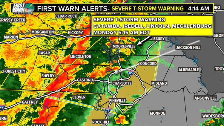
4:40 a.m.: There is a line of severe thunderstorm warnings along the I-77 corridor from Virginia, through Charlotte and North Carolina, and into South Carolina.
4:15 a.m.: Mecklenburg County and surrounding counties are under a Severe Thunderstorm Warning. The warning, which contains a risk for 60 mph winds and tornadoes possible, is in effect for Cabarrus, Catawba, Davie, Alexander, IRedell, Lincoln, Cleveland, Rowan, Gaston, York, and Cherokee.
WCNC
4:05 a.m.: Charlotte-Mecklenburg Police says South Tryon Street is closed at Westinghouse Boulevard due to power lines in the road.
3:50 a.m.: Reports of multiple trees down in Burke County, NC. Radar estimated winds are between 50 and 60 mph.
3:45 a.m.: A Tornado Warning is in effect for Greenville and Pickens counties in the upstate of South Carolina. The First Warn team is monitoring this storm, which could continue into North Carolina within the next hour. There was another tornado near Clemson, South Carolina. That tornado was observed and considered to be considerably danagerous.
3 a.m.: A Severe Thunderstorm Warning issued over several counties in the foothills of North Carolina. The warning, which is in effect for Catawaba, Rutherford, Alander, Iredell, Lincoln, Caldwell, Cleveland, and Burke counties, contains a risk of 60 mph winds and possible tornadoes
Overnight: Tornado Watch issued for Charlotte, upstate South Carolina, and the western North Carolina foothills and mountains.
Previous coverage and forecast:
A “massive storm system” is headed to the Carolinas and across the Southeast Sunday night into Monday morning, said WCNC Charlotte Chief Meteorologist Brad Panovich.
The severe weather outbreak, which began in portions of Texas Saturday before moving moving east on Sunday, is packing damaging winds, scattered tornadoes, and flooding rains across the Southeast.
“This time of year, you have dynamic storms in April,” Panovich explained. “You have the crossover of the strong winds associated with the winter time jet streams – and the springtime heat and humidity. When those two meet up, we get massive severe weather outbreaks.”
Throughout the day Sunday, numerous tornadoes caused damage as the line moved east.
By nightfall, the a Tornado Watch had been extended as far west as Georgia and was expected to be expanded into the Carolinas in the coming hours.
As you head to bed Sunday, make sure you have at least three ways to be awoken by severe weather alerts while your sleeping. Alerts can be received using a NOAA Weather Radio, weather app, or phone call. Make sure your phone is fully charged and not silenced during the night.
“Once the warm front lifts north of us we will ramp up the instability and drive in more moisture that looks to start the day Monday with some significant storms,” said meteorologist Chris Mulcahy.
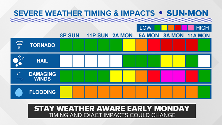
By 2 a.m. Monday morning, the first line of heavy rain and winds are expected across the western North Carolina mountains, including places like Asheville, Boone, and Blowing Rock. Winds could exceed 50 mph.
“The wind energy is crazy with this system,” Panovich said. “It goes bonkers by Monday morning.”
WCNC
By 4 a.m., the heavy rain and wind move across the Piedmont and into Charlotte.
“One thing I can tell you for sure with my highest confidence: we’re going to see widespread damaging winds,” Panovich explained.
By daybreak, the bulk of the severe weather is expected to be moving through the Queen City.
“It will only take less than a minute for there to be damage from these possible damaging straight-line winds,” Mulcahy added. “With the preceding rain on Sunday, our soils will be saturated. This will enhance our risk for downed and uprooted trees across the area.”
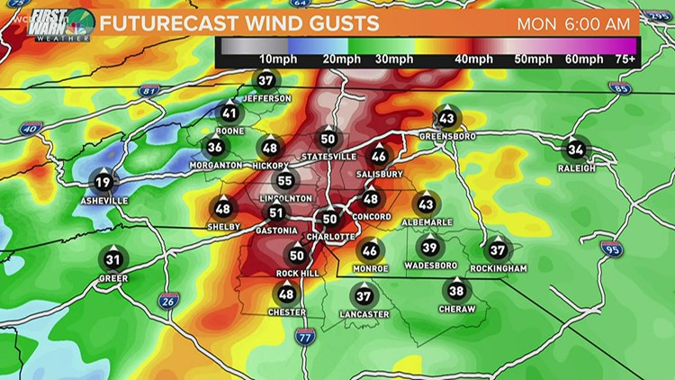
Winds speeds could climb into the 50 or 60 mph range. If the wind were to gust at 74 mph or stronger, it would be as strong as a category one hurricane.
“Tornadoes are like pins. They’re tiny on a map. Compared to the giant swath of damaging winds,” Panovich said. “It’s like a paint roller [across the region].”
Even higher winds would be possible inside thunderstorms and with any potential tornadoes.
“We will likely have what is called a QLCS (Quasi-linear convective system) roll through,” Mulcahy explained. “This means a majority of the line will be a line of strong winds but the “kinks” in the line will allow for brief tornadoes to form and spin down to the surface.”
WCNC
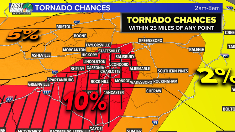
The chance of seeing a tornado had climbed to 10%. While you’re less likely to see a tornado than widespread winds, the few tornadoes that do form could be strong.
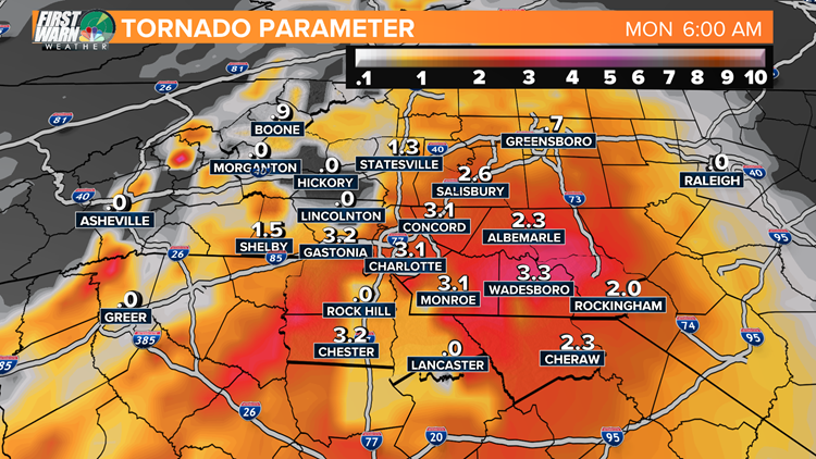
Mulcahy explained anytime there is a 1.0 or higher on the Significant Tornado Parameter (STP), there is a chance for EF2 tornadoes or higher, according to Mulcahy.
“Right now, we are ranging from 1-5,” Mulcahy said. “This has stayed consistent and ideally, we hope this number goes down by tomorrow. This is very high and we have to be prepared for this scenario Monday morning.”
For comparison, the tornado that caused damage across south Charlotte in February was determined to be an EF1.
FROM FEBRUARY: NWS confirms EF-1 tornado in south Charlotte
The chance of severe weather only begins to move out and decrease after 11 a.m. Monday.
WCNC
The exact timing of the severe weather could change as the forecast continues to develop. Timing changes could trend the chances of severe weather up or down – especially if it meant there was more or less heat from the sun fueling the atmosphere.
Either way, now is the time to prepare. Charge your phone. Find your flashlights. And make sure you have multiple ways to receive severe weather bulletins, including options like a NOAA Weather Radio or the WCNC app that will make sound and alert you while you’re sleeping.
Pro tip: Consider NOT putting your phone on Do Not Disturb when you go to sleep Sunday. This way you will hear calls or apps alerting you to any potential severe weather.
More news:
Churches offering virtual fellowship for Easter
List: Charlotte area churches streaming Easter Sunday service
False negatives risks coronavirus spread
Charlotte lights up purple for healthcare workers: Real-time updates Friday, April 10
5 Charlotte Wells Fargo employees test positive for COVID-19