- $40 million to go to underserved SC counties for Hurricane Helene recovery. Here's what you need to know.
- Family honors Air Force veteran Derwin Anderson Jr. after he died in June flash floods
- City of Wilmington addresses flooding on New Centre Drive
- Harnett County fire: Two homes damaged
- Medical examiner identifies 13th victim from massive flash flood in San Antonio
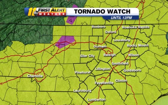
NC weather: Tornado Warning for Cumberland, Harnett, Hoke, Moore counties
RALEIGH, N.C. (WTVD) — Severe weather is moving through central North Carolina on Monday morning.
- Tornado Warning: Cumberland, Harnett, Hoke, Moore counties until 7:45 a.m.
- Severe Thunderstorm Warning: Alamance; Chatham; Durham; Granville; Orange; Person; Randolph until 7:15 a.m.
- Severe Thunderstorm Warning: Cumberland, Harnett, Hoke, Lee, Moore, Scotland counties until 8:15 a.m.
Just before 6:50 a.m., the First Alert Weather Team got confirmation of a tornado on the ground spotted 7 miles south of Mebane headed toward Hillsborough. Don “Big Weather” Schwenneker and Brittany Bell identified this as a radar-confirmed tornado around 6:35 and had been tracking it all morning.
The National Weather Service issued a Tornado Watch until noon for the entire central North Carolina area. A Wind Advisory is also in effect until 4 p.m.
A Tornado Warning has been issued in Central North Carolina…Tune into ABC11 for more details pic.twitter.com/SV2K7142zD
— 𝘿𝙤𝙣 𝙎𝙘𝙝𝙬𝙚𝙣𝙣𝙚𝙠𝙚𝙧 (@BigweatherABC11) April 13, 2020
A Wind Advisory is now in effect until 4pm this afternoon. Sustained winds 20-30 mph, Gusts to 60+mph. Strongest gusts between 6am – Noon, #NCwx pic.twitter.com/ULJaJ5VLBv
— 𝘿𝙤𝙣 𝙎𝙘𝙝𝙬𝙚𝙣𝙣𝙚𝙠𝙚𝙧 (@BigweatherABC11) April 13, 2020
More than 100,000 Duke Energy customers in North and South Carolina were without power as of 5:45 a.m.
Here’s a play-by-play time frame of what to expect for central North Carolina throughout Monday:
RELATED: Duke Energy prepares for outages ahead of Easter weekend storms
Monday Morning
This is when conditions will be the worst. Severe thunderstorms will erupt during this time frame with the main line of storms arriving in our western counties by 7 a.m. The main threat will be damaging straight-line winds with gusts over 60 mph. There may also be flooding, downpours and large hail. In addition, there is the possibility of a tornado for all of central North Carolina, however, the most likely place to see an isolated tornado will be in the sandhills and west of the sandhills.
Monday Afternoon
By Afternoon there may be a lingering shower in a few spots across central North Carolina, but this is when most of us begin to dry out. It will still be windy even after the storms have passed. Then by late afternoon, some sunshine will break through the clouds and allow temperatures to rise into the low 80s.
Monday Night
Monday evening and night will be mostly clear and much cooler with overnight lows in the upper 40s/low 50s.
RELATED | Tornado watch vs warning: What to do when you see alert messages
Copyright © 2020 WTVD-TV. All Rights Reserved.