- Austin leaders consider expanding wildfire protection plan
- Large hail, strong winds and tornado threat possible into Thursday evening
- Large hail, tornado threat possible Thursday evening
- Jaccob Slavin scores in OT as the Hurricanes beat the Capitals in Game 1 of their 2nd-round series
- 5 On Your Side: What happened to cars flooded during Hurricane Helene?
Gardner: It'll be a beautiful Wednesday before severe weather tomorrow

Wednesday will be beautiful before a threat for severe weather moves in Thursday, according to WRAL meteorologist Elizabeth Gardner.
“Enjoy today because tomorrow will be a completely different story,” Gardner said.
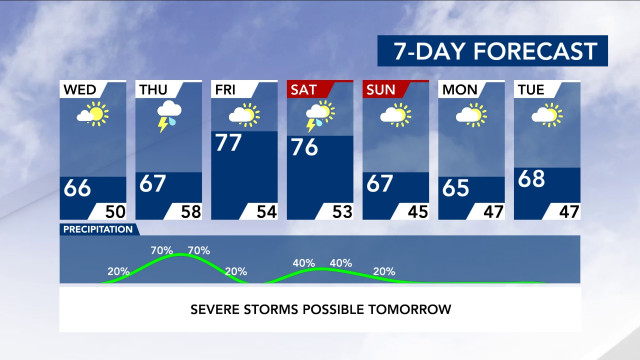
A high pressure system will keep things dry Wednesday before Thursday’s severe weather. Wednesday will be cooler, but beautiful, with plenty of sunshine and a high around 66 degrees in Raleigh.
Rain could begin late Wednesday night or Thursday morning.
Severe weather won’t move in until after lunchtime on Thursday, and storms could continue into Friday morning.
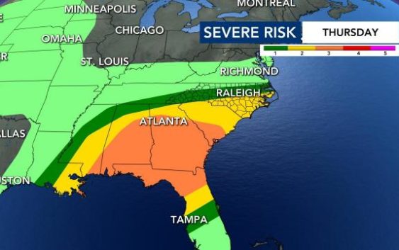
According to Gardner, the Triangle northward is under a level 1 risk for severe weather Thursday afternoon.
Areas south of the Triangle are under a level 2 risk, which means gusty winds, hail or an isolated tornado are more likely than they will be in Raleigh.
Gardner said everyone could wake up to rain Thursday, and the entire day could be blustery.
If the rain is heavy enough on Thursday, it could mean less storms, Gardner said.
“Heavy rain tends to stabilize the atmosphere,” Gardner said. “Tomorrow we’ll really have to get an hour-by-hour look at what is happening.”
The greatest severe weather threat is Thursday afternoon and evening.
“It could be a good soaker,” Gardner said, adding that an inch of rain could fall, causing isolated flooding.
After the storms move away, Friday looks sunny and dry, although another system could bring rain and thunderstorms to the area on Saturday.

