- Severe weather leads to fallen trees, car crashes and flooding around the Triangle
- New video shows vehicles being swept away in historic, deadly flash floods in SA on June 12
- $40 million to go to underserved SC counties for Hurricane Helene recovery. Here's what you need to know.
- Family honors Air Force veteran Derwin Anderson Jr. after he died in June flash floods
- City of Wilmington addresses flooding on New Centre Drive
Tornado Watch in effect: When to expect storms in the Houston area

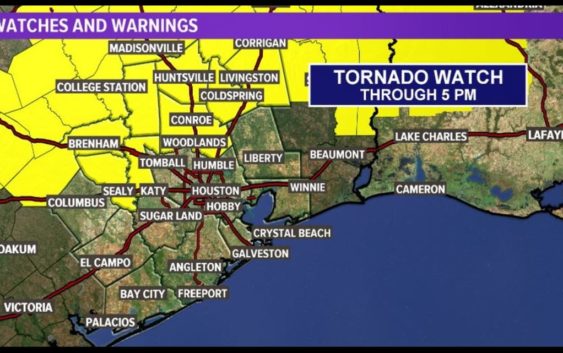
HOUSTON — Areas north and northwest of Houston and into Louisiana are under a Tornado Watch until 5 p.m. Wednesday.
This includes Austin, Grimes, Polk, Montgomery, San Jacinto, Waller, Washington and Walker Counties:
TRACK THE WEATHER: Houston weather radar
GET ALERTS ON YOUR PHONE: Download the KHOU 11 app
A strong upper level system will bring a chance of storms. Some of these storms could be strong to severe, so make sure to stay “weather aware” — especially for our neighbors north of town.
TIMELINE: When to expect today’s storms
12 PM — Now is when you’ll want to start tracking the radar as the rain/storm chance goes up to 30%
2 PM — 60% chance for rain, storms – especially after 3 p.m. and into the evening
4 PM — Chance for storms, isolated showers continues through the afternoon; temps in the 80s; best chance for severe weather is north of Hunstville, although we can’t rule out an isolated strong storm here.
Chance for storms, isolated rain continues from late afternoon and into the evening
10 PM — Entering the late evening hours Wednesday the storms will have cleared out but some light, scattered showers may remain overnight
The rain, showers will clear out by the early-morning hours Thursday.
Most accumulations look less than a half an inch- but an isolated storm could produce more than that. Keep your guard up through the afternoon just to be on the safe side. Stay weather ready- of course if you hear thunder it is time to get in doors and make sure you have your alerts turned on if you have the KHOU11 app.
Thursday we will see the sunshine return. With that sunshine, get ready for a quick warm up… if you are keeping track of the days… Keep an eye on the temperatures on Friday. We could be warming up quite a bit!
A dry cool front will drop the humidity and make for a much more comfortable weekend.