- How sewage floods at home turned into nightmares for Raleigh families
- Rock Hill storm damage costs are 'somewhere around $5 million.' That number doesn't include damage to personal property
- Rock Hill storm damage costs are 'somewhere around $5 million.' That number doesn't include damage to personal property
- ‘Somewhere around $5 million’ | Rock Hill officials see major storm damage costs
- The deadliest tornadoes to ever hit Austin
Severe weather threat for today includes severe thunderstorms, high winds, and heavy rain
CHARLOTTE, N.C. — Severe weather Thursday could bring a risk of damaging wind and isolated tornadoes to Charlotte and the Carolinas.
Thursday will not be a washout but there are a few pulses of rain and storms that some of those pulses could lead to strong to severe storms.
Have the umbrella to start the day but by the late morning into the afternoon, some will see a brief lull in the rain which will be a precursor to the chance for severe storms.
The Charlotte region was upgraded to a high risk for strong storms and there are also some ingredients pointing towards a chance for rotating storms that could lead to supercells and tornadoes.
WHEN: The current window is wide open from 2-8 PM Thursday afternoon and early evening but realistically this will be a mid to late afternoon event (3-6 PM) for the Charlotte area. After that, there is a chance for one more last hurrah of showers but likely this will not be as strong as the storms arriving at the peak of the daytime heating.
WHERE: From Charlotte and the I-85 to towns and cities south and west of that line. Right now our South Carolina counties and SE NE Carolina Counties (Union, Anson and Richmond) have the best chance for strong to severe storms.
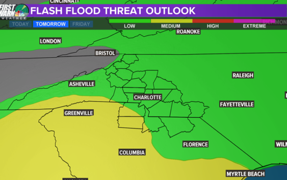
WHAT: Strong damaging winds but also a chance for tornadoes. Damaging winds and downed trees will be the highest concern and we now have a 30% south of the I-85 corridor. The further south you head (South Carolina) the more likely Flash Flooding is and storms in general.

WCNC
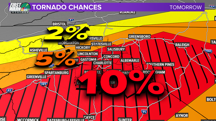
TORNADOES: We have a real chance to see a few tornadoes across out viewing area and the Carolinas in general. See this graphic below. From Charlotte and areas south, we are in the northern tier of the “Significant” chance for tornadoes and it is up to 10%. For a tornado chance.,.. that is quite HIGH. That means 1 out of every 10 thunderstorms could be rotating and produce a tornado. Regardless… WIND IS WIND! May it be from straight-line winds or ones that twist. The danger is there for both.
WCNC
What’s NEXT: Another low pressure system with a strong warm front will swoop across our region Saturday morning into the afternoon. This is still far out but this could be a similar scenario to what is on tap for Thursday. Keep this in mind and be “Weather Aware” Thursday and this coming Saturday.
RELATED: Explaining hail and what causes it: WCNC Charlotte Weather School
RELATED: Explaining tornadoes: WCNC Weather School
Copyright 2018 WCNC