- Severe weather leads to fallen trees, car crashes and flooding around the Triangle
- New video shows vehicles being swept away in historic, deadly flash floods in SA on June 12
- $40 million to go to underserved SC counties for Hurricane Helene recovery. Here's what you need to know.
- Family honors Air Force veteran Derwin Anderson Jr. after he died in June flash floods
- City of Wilmington addresses flooding on New Centre Drive
Severe weather threat no longer in effect for Charlotte
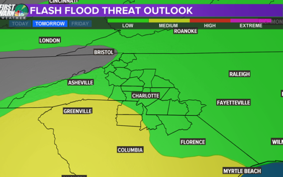
CHARLOTTE, N.C. — A severe weather threat is no longer in effect for the Charlotte-area.
According to meteorologist Chris Mulcahy, Charlotte is no longer in a high or even low risk for severe weather later this afternoon.
Mulcahy said the rain Charlotte received this morning is stabilizing us.
“We still have a chance for a few storms this afternoon but that should be about it,” Mulcahy said.
WHEN: The main time frame is from 2-8 PM this afternoon and early evening. After that there is a chance for one more round of rain but likely this will not be as strong as the storms arriving at the peak of the daytime heating.
WHERE: Right now our South Carolina counties and SE NE Carolina Counties (Union, Anson and Richmond) have the best chance for strong to severe storms.
WHAT: Strong damaging winds but also a chance for tornadoes. Damaging winds and downed trees will be the highest concern. Flash flooding is more of a threat to the south of the Charlotte area.

WCNC
What’s NEXT: Another low-pressure system with a strong warm front will swoop across our region Saturday morning into the afternoon. This is still far out but this could be a similar scenario to what is on tap for Thursday. Keep this in mind and be “Weather Aware” Thursday and this coming Saturday.
RELATED: Explaining hail and what causes it: WCNC Charlotte Weather School
RELATED: Explaining tornadoes: WCNC Weather School
Copyright 2018 WCNC