- Texas flooding: Emergency crews rescue stranded residents
- “We lost everything”: East Texas residents confront their future after flooding
- Conroe police officer critically injured in Trinity County tornado dies
- Flood risk and severe weather threat for Central Texas over the weekend
- ‘Hasn’t been this bad since Harvey': Woodloch residents in Montgomery County brace for more flooding
Forecast: Overnight severe weather threat
Weather Outlook:
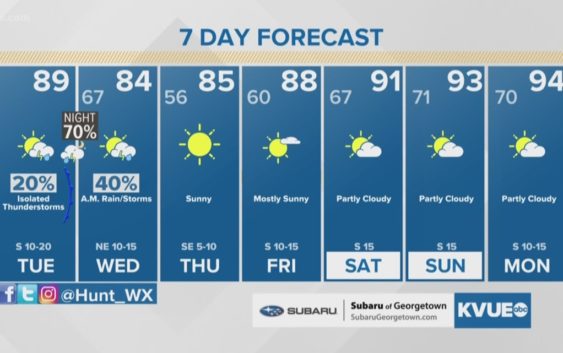
Scattered showers and storms are in the forecast for tonight. A few storms could be strong or severe. The main concern will be from storms producing strong winds. For Wednesday, a morning shower or storm then clearing skies, breezy and cooler in the afternoon with highs in the upper 70s and low 80s. Clear and cool Wednesday night with lows in the mid 50s. Sunny and nice Thursday. Breezy and hotter Friday through early next week. Highs will be in the low to mid 90s and heat index values will be around 100 degrees.
TUESDAY NIGHT:
Scattered showers and storms late this evening through the overnight hours. A few storms could be severe. South wind at 10 to 15 mph.
LOW: 68°
WEDNESDAY:
A morning shower or storm, then clearing skies in the afternoon. A breezy north wind at 10 to 20 mph.
HIGH: 83°
THURSDAY:
Sunny and warm. North wind turning to the southeast at 5 mph.
HIGH: 85°
RELATED: Today’s Allergy Report
Stay with KVUE on social media and download the KVUE News app so you can stay ahead of the storm: kvue.com/app.