- Mosquito activity on the rise due to rainfall, flooding across Texas
- Volunteers help Conroe community clean up in wake of flooding in Montgomery County
- Why leaders are urging NC residents to start hurricane prep now
- Storms could produce hail, damaging winds south of Charlotte
- Large hail and strong winds cause damage in San Marcos and the Hill Country
Houston Forecast: Severe weather threat tonight
Try to get out early today before the rain kicks in.
HOUSTON — You are waking up mild and muggy this morning. You may want to get outside early because showers and a few storms will be possible this afternoon.Even though the main event with the risk of severe weather will happen overnight.
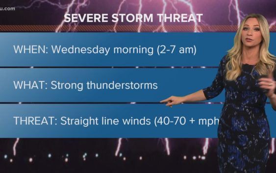
The Storm Prediction Center has the Houston metro area in a ‘slight risk’ (2 out of 5). Areas just to our north (north of the College Station- Livingston line) is at a threat level 3. The KHOU weather team will be tracking the potential for strong straight line damaging winds ahead of a cold front that will be pushing through overnight.
Take another look at that Futuretrack radar for Wednesday morning. See how the storm line segments (red) are bent… or ‘bowing’ out? That’s what we call a ‘bow-echo’ and it indicates the threat for damaging straight line winds.
GET ALERTS ON YOUR PHONE: Download the KHOU 11 app
We ask that you stay weather aware and since this is an overnight event and we recommend that you have multiple ways of receiving weather alerts. The KHOU app is one of those ways that we highly recommend. Here’s what you need to know:
Once we get past Wednesday morning, rain chances will decrease and things will start to heat up! Full sunshine and big temperatures will greet us heading into the end of the week and weekend. We’ll make our way into May, on Friday, with highs into the 90s. The record daytime highs for the weekend are; Friday – 94 in 1947, Saturday – 96 in 1964, and Sunday – 93 in 1890. While we won’t be look to race past these records, we’ll certainly be in their ballpark range.
TRACK THE WEATHER: Houston weather radar
GET ALERTS ON YOUR PHONE: Download the KHOU 11 app