- Austin leaders consider expanding wildfire protection plan
- Large hail, strong winds and tornado threat possible into Thursday evening
- Large hail, tornado threat possible Thursday evening
- Jaccob Slavin scores in OT as the Hurricanes beat the Capitals in Game 1 of their 2nd-round series
- 5 On Your Side: What happened to cars flooded during Hurricane Helene?
Severe weather threat increases for Triangle, will be worse in southern counties
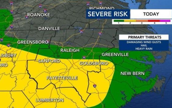
Raleigh, N.C. — A level 2 threat for severe weather in our southern counties could bring the Triangle some rain and storms on Tuesday evening, according to WRAL meteorologist Elizabeth Gardner.
Across central North Carolina, conditions will stay cool and cloudy for much of the day, with highs in the 50s to lower 60s. There is a level 1 risk for severe weather in parts of the Triangle and a level 2 risk in some areas southwest of the Triangle, including Sanford, Goldsboro, Fayetteville and Lumberton.
A chance of rain and storms will return Tuesday night, mostly south of the Triangle. Gardner said the best chance for severe weather, including the potential for hail, heavy rain and strong winds, will be Tuesday evening and at night.
The Triangle is included in the severe weather risk, but conditions will be worse to the south.

There will be a wide range of temperatures across the viewing area on Tuesday. In Raleigh, temperatures should stay in the upper 50s to low 60s, much cooler than usual for early May. In Fayetteville, the high will be in the low 70s.
The normal high for May 5 is around 77 degrees.
Track the rain with the DualDoppler5000.
Gardner said there is a marginal risk of isolated thunderstorms over southwest and southern counties Tuesday afternoon and evening.

Wednesday and Thursday will be much different, with highs around 67 degrees in Raleigh. There could be some afternoon rain on Wednesday, but Thursday will be clear and sunny.
Friday will be cloudy but warm, with a high around 72 degrees.
The weekend looks sunny and milder, with highs in the mid 60s. Mother’s Day will be beautiful but cool, with a high in the low to mis 60s.