- Mosquito activity on the rise due to rainfall, flooding across Texas
- Volunteers help Conroe community clean up in wake of flooding in Montgomery County
- Why leaders are urging NC residents to start hurricane prep now
- Storms could produce hail, damaging winds south of Charlotte
- Large hail and strong winds cause damage in San Marcos and the Hill Country
Tornadoes, large hail possible with storms across southern part of NC tonight
Raleigh, N.C. — A level 2 threat for severe weather in our southern counties could bring the Triangle some rain and storms on Tuesday evening, according to WRAL meteorologist Mike Maze. There is a level 1 risk for severe weather in parts of the Triangle and a level 2 risk in some areas southwest of the Triangle, including Sanford, Goldsboro, Fayetteville and Lumberton.
“We have a warm front moving into the southern part of the state this evening bring some warmer and more humid air. Along with the front there is upper level energy that will ride through the region. The concern is that due to the front in the vicinity that some severe storms could have damaging wind gusts and a tornado or two,” Maze said.
The best chance for severe weather, including the potential for hail, heavy rain and strong winds, will be Tuesday evening after 6 p.m., Maze said.
The Triangle is included in the severe weather risk, but conditions will be worse to the south.
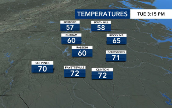
Tuesday was markedly cooler than recent days have been, with temperatures only getting into the 60s in Raleigh. The normal high for May 5 is around 77 degrees.
Track the rain with the DualDoppler5000.

Wednesday and Thursday will cool and cloudy, with highs around 67 degrees in Raleigh.
Friday will be cloudy but warm, with a high around 72 degrees.
The weekend looks sunny and milder, with highs in the mid 60s. Mother’s Day will be beautiful but cool, with a high in the low to mid 60s.