- North Carolina behind on hurricane preparedness, study shows
- North Carolina way behind on hurricane preparedness, study shows
- New hurricane preparedness report doesn't rank North Carolina well
- New hurricane preparedness report doesn't rank North Carolina well
- Southport hosts annual Hurricane Expo ahead of the 2024 season
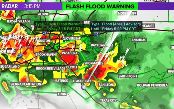
Strong storms prompt flash flood warning for Harris County until 5:15
We’re expecting heavy rain on Saturday that could lead to street flooding.
Strong storms with heavy rain, thunder and lightning are pushing through the Greater Houston area this afternoon.
A flash flood warning is in effect for Harris County until 5:15 p.m.
KHOU 11 Chief Meteorologist David Paul said the storms have the potential to produce minor street flooding in areas.
RELATED: Map of power outages in Houston
The National Weather Service has issued a significant weather advisory for northwestern Galveston, northwestern Brazoria and southern Harris counties until 4 p.m.
Wind gusts of 50-55 mph are possible.
“Torrential rainfall is also occurring with this storm and may lead to localized flooding,” the weather service said. “Do not drive your vehicle through flooded roadways.”
We’ll be on weather watch this Saturday as abundant moisture and an upper level disturbance combine to produce the threat for heavy rain.
A Flash Flood Watch has been issued for San Jacinto, Polk, Montgomery, Liberty, Colorado, Waller, Harris, Chambers, Wharton, Fort Bend, Matagorda, Brazoria and Galveston counties from Friday night until 7 p.m. Saturday.
The heaviest of the rain is expected Saturday morning. Rainfall rates of 3 inches per hour will be possible. Rainfall totals of 2 to 4 inches expected widespread with isolated areas seeing 6 inches or more. A few of these storms may train, and these storms will be strong enough to be capable of flooding roads, low water crossings, small creeks and bayous.
By Saturday evening, the threat will be ending and it looks like it may not be a washout of a weekend after all! A few scattered showers may be lingering through Sunday before a dry air mass moves in for next week with plenty of sunshine.
Get the KHOU11 app and stay close to the weather with us this weekend.