- Rock Hill storm damage costs are 'somewhere around $5 million.' That number doesn't include damage to personal property
- Rock Hill storm damage costs are 'somewhere around $5 million.' That number doesn't include damage to personal property
- ‘Somewhere around $5 million’ | Rock Hill officials see major storm damage costs
- The deadliest tornadoes to ever hit Austin
- Whiteville resident recalls events from Tuesday nights tornado
National Hurricane Center upgrades system in Atlantic to tropical depression
The National Hurricane Center has upgraded the storm system currently in the Atlantic Ocean into the first tropical depression of the season.
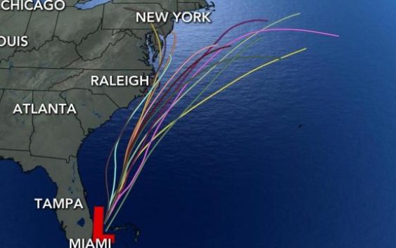
Tropical Depression One is now located 125 miles east of Melbourne, Fla., as of the 5 p.m. summary that was issued by the NHC. It is measured at 35 mph and is moving north northeast at 13 mph. A tropical storm watch has been issued for the North Carolina coast from Surf City to Duck, including the Pamlico Sound and Albemarle Sound.
A tropical storm watch means that tropical storm conditions are possible within the watch area, generally within 48 hours.
According to WRAL meteorologist Elizabeth Gardner, if the system does form into either a tropical storm or hurricane, it will likely stay offshore. It would be named Arthur and mark the sixth year in a row a system formed earlier than hurricane season, which officially begins June 1.
The system will develop the most over the weekend and Monday and could create a high rip current danger at North Carolina beaches this weekend as it moves northeast.
On Sunday night, the coast could see up to 40 mile per hour winds. That’s probably as strong as the winds will get, Gardner said. But, it could still cause some severe erosion on the Outer Banks.
Beaches near Atlantic Beach will see the highest threat for rip currents. Other beaches along the coast have a “moderate” risk for the currents.
“If you go to the beach, you need to be careful,” Gardner said.
If this system becomes a tropical storm, the first of the season, it would be named Arthur and would mark the sixth year in a row that a named system formed in the Atlantic before the official start of hurricane season on June 1.
The forecast track takes the system from the Bahamas and northeast, staying off the coast of the southeastern United States.

The system has a 70% chance of forming over the next 72 hours and a 90% change of reaching tropical storm strength by Thursday.
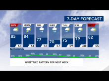
A cold front that will come in and push the high-pressure, subtropical system to the east could also bring some rain to North Carolina on Monday and Tuesday, Gardner said.
Because of that front, plan to see some cooler temperatures when the cold front does come in.
Even though the system is forming, we are still going to see a trend of warmer weather as we head into the weekend. Saturday’s temperatures will be inching toward the 90s.