- WATCH: Video Shows Confirmed Tornado touches down in Columbus County
- Residents begin clean up after storms, apparent tornado roll through NC Tuesday
- Flooding lingers in Liberty County neighborhoods near Trinity River with more rainfall expected
- North Carolina behind on hurricane preparedness, study shows
- North Carolina way behind on hurricane preparedness, study shows
Tornado Warning In Effect For NW Bexar County, Including Alamo Heights, Leon Valley, And Helotes
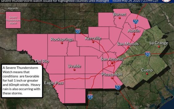
Another line of thunderstorms packing heavy rain, hail, and gusty winds pushed across South Central Texas, including San Antonio, on Sunday night.
A tornado warning was issued for Medina and Northwest Bexar County until 8:30 p.m.
Tornado Warning including Leon Valley TX, Helotes TX, Alamo Heights TX until 8:30 PM CDT pic.twitter.com/YyRnJiwei9
— NWS Austin/San Antonio (@NWSSanAntonio) May 25, 2020
Severe thunderstorm watches and warnings and flash flood watches and warnings were posted for some areas of the region after a previous rain on Saturday night had already left the ground saturated.
Flash flood warnings were placed in effect for Real, Uvalde, Bandera and Medina Counties to the west of San Antonio after rain up to three inches fell on some spots.
Meteorologist Eric Platt of the National Weather Service in New Braunfels saw forecast models earlier in the day.
“We’re expecting a complex of thunderstorms to be moving in from the west, and so the main concern we’re looking at is the possibility of some large hail, damaging winds with this line of thunderstorms and also some heavy rainfall,.” he said.
Hail the size of ping pong balls and 60-mile an hour winds were reported around Carrizo Springs in Dimmit County.
Half dollar-sized hail was reported northwest of Dilley in Frio County.